Log inSign up
NWS Albuquerque
54.4K posts
Image
user avatar
NWS Albuquerque
@NWSAlbuquerque
Official X account for the Albuquerque National Weather Service. Details: weather.gov/nws_x
Albuquerque, NM
weather.gov/abq
Joined February 2012
310
Following
28.8K
Followers
RepliesRepliesMediaMedia

New to X?

Sign up now to get your own personalized timeline!

Create account

By signing up, you agree to the Terms of Service and Privacy Policy, including Cookie Use.

Terms·Privacy·Cookies·Accessibility·Ads Info·© 2026 X Corp.
Don't miss what's happening
People on X are the first to know.
Log inSign up
  • Pinned
    user avatar
    NWS Albuquerque
    @NWSAlbuquerque
    Jan 26
    The Albuquerque NWS serves northern & central New Mexico. Our neighbors in Santa Teresa (@NWSElPaso) serve southwestern & south central NM. The @NWSMidland office serves southeastern NM. For statewide weather forecast graphics, check out: weather.gov/abq/newmexicog…
    The map of New Mexico shows the 3 different National Weather Service offices that cover the state. NWS Albuquerque covers the northern 25 counties, NWS El Paso covers southwestern and south central New Mexico. NWS Midland covers Eddy and Lea counties in southeastern New Mexico.
    11K
  • user avatar
    NWS Albuquerque
    @NWSAlbuquerque
    1h
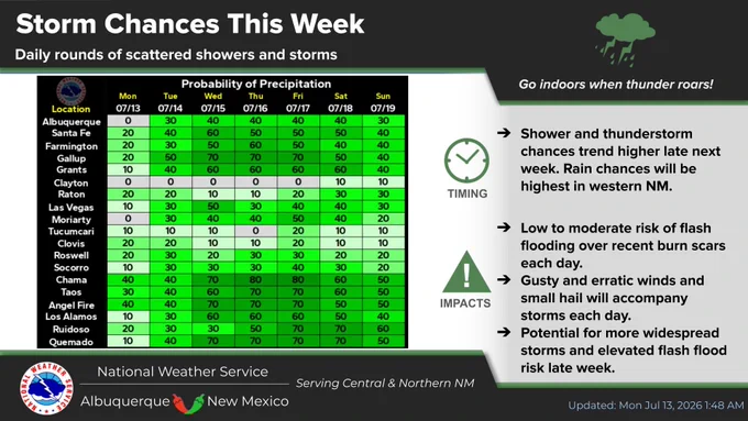
    Isolated storms will favor northwest and southeast NM, with relatively dry conditions in the central portion of the state. Rain chances will trend higher late week as storms become more numerous. #NMwx
    The graphic shows high temperatures and rain chances around central and northern New Mexico for today.
    The graphic shows rain chances for select sites around central and northern New Mexico this week. Scattered showers and storms become more numerous late week.
    175
  • user avatar
    NWS Albuquerque
    @NWSAlbuquerque
    10h
    ⛈️ On Monday, scattered afternoon thunderstorms will favor the northern and southern mountains of NM, as well as the east central plains. Brief downpours, dangerous cloud-to-ground lightning, gusty winds to 45 mph & small hail will be common with stronger storms. #NMwx
    The maps of northern and central New Mexico indicate that on Monday, scattered afternoon thunderstorms will favor development over the northern and southern mountains of New Mexico, as well as the east central plains. Brief downpours, dangerous cloud-to-ground lightning, gusty winds to 45 mph, and small hail will be common with the stronger storms.
    872
    user avatar
    NWS Albuquerque
    @NWSAlbuquerque
    10h
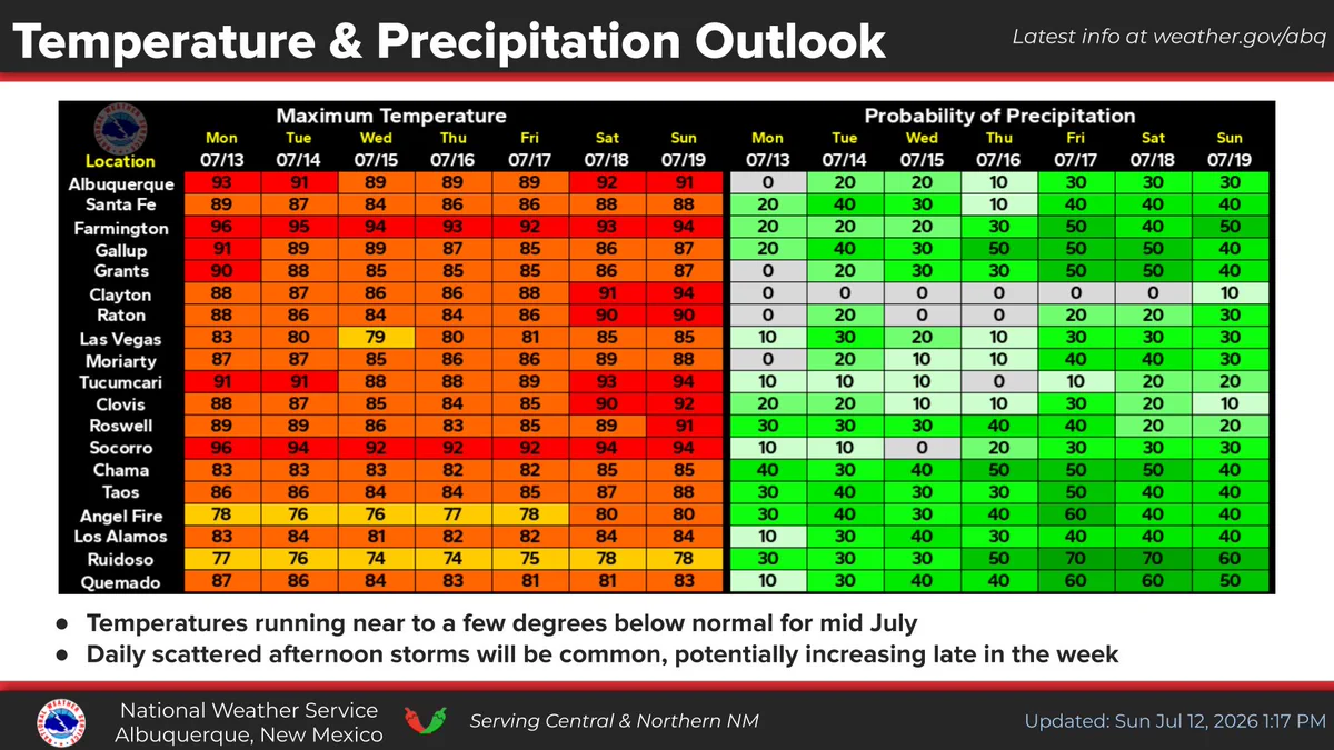
    🌡️📉 Temperatures trend a few degrees cooler through the end of the week, running near to slightly below normal. ⛈️ Scattered showers and storms are likely around central and northern New Mexico each of the next seven days. Coverage will likely trend higher late week. #NMwx
    The high temperature table indicates that readings will trend a few degrees cooler through the end of the week, running near to slightly below normal. Scattered showers and storms are likely around central and northern New Mexico each of the next seven days. Coverage will likely trend higher late week.
    401
  • user avatar
    NWS Albuquerque
    @NWSAlbuquerque
    15h
    If you have ever heard us talk about “outflow boundaries” there are some prominent examples over east central NM, depicted by bluish lines emanating outward from storms. These outflow boundaries are like “mini cold fronts” & can have gusty winds associated with them. # NMwx
    Image
    00:00
    1K
  • user avatar
    NWS Albuquerque
    @NWSAlbuquerque
    Jul 12
    Isolated to scattered storms are expected around central and northern New Mexico today and will stick around each afternoon through the end of the week. Temperatures trend closer to seasonal averages early in the week. #NMwx
    This graphic shows the severe weather outlook for Sunday. There is a Marginal risk of severe storms in the east central plains.
    The graphic shows rain chances and central and northern New Mexico today and tomorrow. Scattered showers and storms are likely each da.
    The graphic shows rain chances for select sites around central and northern New Mexico for the next seven days. Scattered showers and storms are likely each day.
    1.1K
  • user avatar
    NWS Albuquerque
    @NWSAlbuquerque
    Jul 11
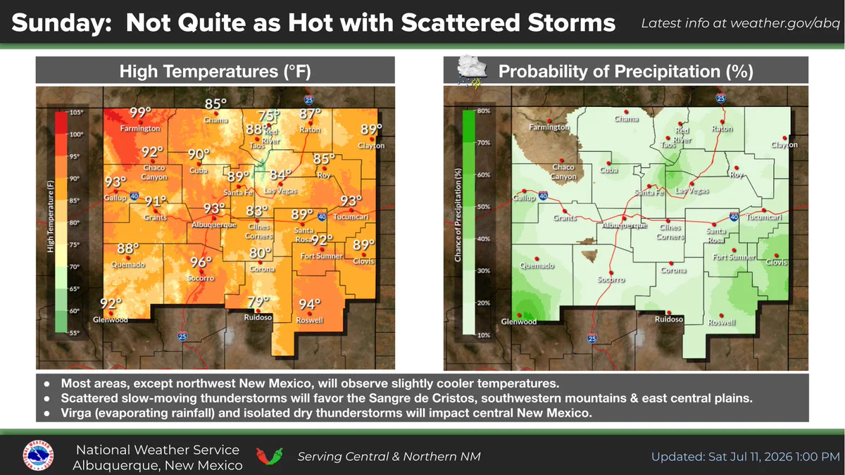
    ⛈️ Isolated to scattered thunderstorms will develop Sunday afternoon with the Sangre de Cristos, southwest mountains & east central plains being the favored areas. Temperatures will not be quite as hot, except in northwestern areas of New Mexico. #NMwx
    The maps of northern and central New Mexico indicate that isolated to scattered thunderstorms will develop Sunday afternoon with the Sangre de Cristo mountains, southwestern mountains, and east central plains being the favored areas. Any storms in central New Mexico will produce less rainfall due to evaporation (virga). Temperatures will not be quite as hot, except in northwestern areas of New Mexico.
    1.1K
    user avatar
    NWS Albuquerque
    @NWSAlbuquerque
    Jul 11
    ⚡️ 🌬️ A few thunderstorms in the east central plains will have a tendency to turn strong to severe on Sunday. In addition to heavy downpours & lightning, damaging winds would be main threat. Any storms in central NM will produce less rainfall due to evaporation (virga). #NMwx
    The graphic indicates that a few thunderstorms in the east central plains will have a tendency to turn strong to severe on Sunday. In addition to heavy downpours and lightning, damaging winds would be the main threat.
    451
    user avatar
    NWS Albuquerque
    @NWSAlbuquerque
    Jul 11
    🌡️ Temperatures for the week ahead will run near to a few degrees below normal for mid July. Daily scattered afternoon storms will be common. #NMwx
    359
  • user avatar
    NWS Albuquerque
    @NWSAlbuquerque
    Jul 11
    Aviso de Inundación Repentina incluye Ruidoso NM, Ruidoso Downs NM, Hollywood NM hasta las 7:15 PM MDT
    Este gráfico muestra la localización en el mapa de un aviso de inundación repentina. El aviso estará en efecto hasta las 7:15 PM MDT. El aviso incluye a Ruidoso NM, Ruidoso Downs NM, Hollywood NM. El aviso incluye The South Fork and McBride burn scar en y el sur centro del condado de Lincoln en el centro de New Mexico. ¡Aléjese rápidamente de las zonas quemadas! ¡Muévase a un terreno más alto inmediatamente! Hay 13,496 personas bajo este aviso incluyendo 6 escuelas y 1 hospital.
    839
  • user avatar
    NWS Albuquerque
    @NWSAlbuquerque
    Jul 11
    Flash Flood Warning including Ruidoso NM, Ruidoso Downs NM and Hollywood NM until 7:15 PM MDT
    This graphic displays a flash flood warning plotted on a map. The warning is in effect until 7:15 PM MDT. The warning includes Ruidoso NM, Ruidoso Downs NM and Hollywood NM.  This warning is for The South Fork and McBride burn scar in and South Central Lincoln County in central New Mexico. Quickly move away from the burn scar area! Move immediately to higher ground! There are 13,496 people in the warning along with 6 schools and 1 hospital.
    664
  • user avatar
    NWS Albuquerque
    @NWSAlbuquerque
    Jul 11
    Aviso de Inundación Repentina incluye Nogal NM hasta las 6:45 PM MDT
    Este gráfico muestra la localización en el mapa de un aviso de inundación repentina. El aviso estará en efecto hasta las 6:45 PM MDT. El aviso incluye a Nogal NM. El aviso incluye el centro del condado de Lincoln en el centro de New Mexico. ¡Evite caminar o manejar su vehículo a través de áreas inundadas! ¡Muévase a un terreno más alto inmediatamente! Hay 1,059 personas bajo este aviso incluyendo 0 escuelas y 0 hospitales.
    618
  • user avatar
    NWS Albuquerque
    @NWSAlbuquerque
    Jul 11
    Flash Flood Warning including Nogal NM until 6:45 PM MDT
    This graphic displays a flash flood warning plotted on a map. The warning is in effect until 6:45 PM MDT. The warning includes Nogal NM.  This warning is for Central Lincoln County in central New Mexico. Avoid walking or driving through flood waters! Move immediately to higher ground! There are 1,059 people in the warning along with 0 schools and 0 hospitals.
    789
  • user avatar
    NWS Albuquerque
    @NWSAlbuquerque
    Jul 11
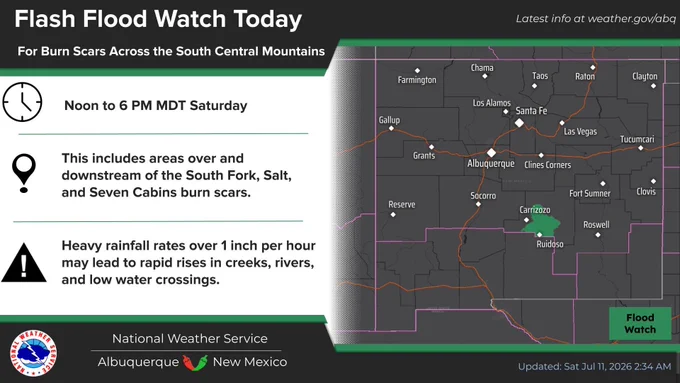
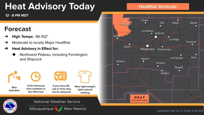
    Scattered storms today will favor areas along and east of the central mountain chain. Slow moving storms over the Ruidoso area burn scars may produce flash flooding today which is why a Flash Flood Watch is in effect. Daily rounds of showers & storms stick around next week. #NMwx
    A Flash Flood Watch is in effect for the South Central Mountains, including the Ruidoso area burn scars for Saturday afternoon.
    A Heat Advisory is in effect for the Northwest Plateau, including Farmington for Saturday.
    There is a Marginal risk of severe storms this afternoon in eastern, south central, and southwest New Mexico. Damaging wind gusts is the main threat.
    Scattered showers and storms are expected from Sunday onwards around central and northern New Mexico.
    852
  • user avatar
    NWS Albuquerque
    @NWSAlbuquerque
    Jul 11
    Through 915 PM MDT, severe thunderstorms will move through Quay and northern Roosevelt Counties with damaging wind gusts. A wind gust of 60 mph was measured near Ragland around 8 PM. #nmwx
    Image
    00:00
    862
  • user avatar
    NWS Albuquerque
    @NWSAlbuquerque
    Jul 11
    Aviso de Tormenta Severa incluye Clovis NM, Portales NM, Texico NM hasta las 9:15 PM MDT
    Este gráfico muestra la localización en el mapa de un aviso de tormenta severa. El aviso estará en efecto hasta las 9:15 PM MDT. El aviso incluye a Clovis NM, Portales NM, Texico NM. El aviso incluye el sur del condado de Curry en el este centro de New Mexico y el centro del condado de Roosevelt en el este centro de New Mexico. Las amenazas asociadas a este aviso son: ráfagas de viento de 60 MPH y granizo del tamaño de una pequeña canica. Hay 64,566 personas bajo este aviso incluyendo 34 escuelas y 2 hospitales.
    715
  • user avatar
    NWS Albuquerque
    @NWSAlbuquerque
    Jul 11
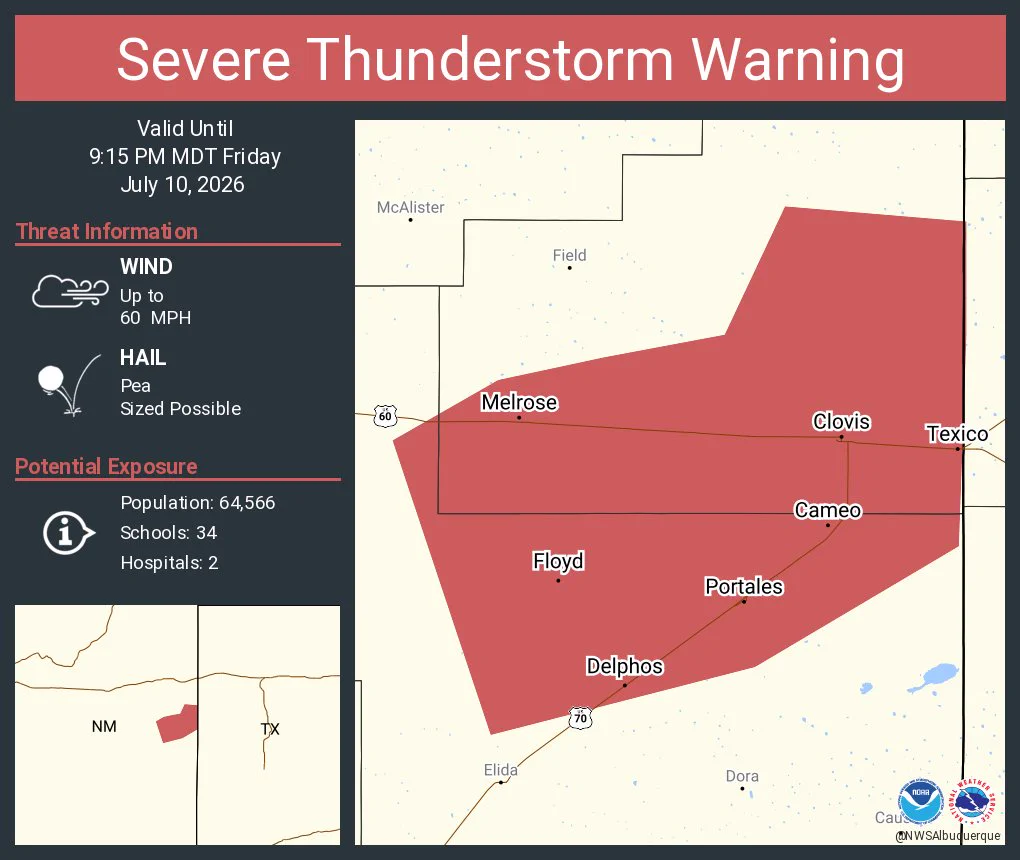
    Severe Thunderstorm Warning including Clovis NM, Portales NM and Texico NM until 9:15 PM MDT
    This graphic displays a severe thunderstorm warning plotted on a map. The warning is in effect until 9:15 PM MDT. The warning includes Clovis NM, Portales NM and Texico NM.  This warning is for Southern Curry County in east central New Mexico and Central Roosevelt County in east central New Mexico. The threats associated with this warning are wind gusts up to 60 MPH and pea sized hail. There are 64,566 people in the warning along with 34 schools and 2 hospitals.
    683
Advertisement
Advertisement