1. X
  2. NWS Chicago
Log inSign up
NWS Chicago
49.7K posts
Image
user avatar
NWS Chicago
@NWSChicago
Official X account for the National Weather Service Chicago. Details: weather.gov/nws_x
Romeoville, IL
weather.gov/chicago
Joined July 2012
1,038
Following
199.5K
Followers
RepliesRepliesMediaMedia

New to X?

Sign up now to get your own personalized timeline!

Create account

By signing up, you agree to the Terms of Service and Privacy Policy, including Cookie Use.

Terms·Privacy·Cookies·Accessibility·Ads Info·© 2026 X Corp.
Don't miss what's happening
People on X are the first to know.
Log inSign up
  • user avatar
    NWS Chicago
    @NWSChicago
    9h
    Heads up! Dangerous swimming conditions are expected to develop at southern Lake Michigan beaches this evening and last through Wednesday night, possibly stretching into early Thursday. Please plan accordingly if you're heading to the beach! Know before you go!
    Headline: High Swim Risk Tonight - Wednesday.  Sub Headline: Stay dry when waves are high! What To Expect.  Dangerous waves up to 10 feet and hazardous boating conditions.  Life threatening currents.  This evening through Wednesday.  Choppy, less-than-favorable conditions this afternoon may be dangerous for weak swimmers.  Southern Lake Michigan Beaches.  In Illinois and northwest Indiana.  What To Do.  Stay out of the water! Obey posted signs and closures. Avoid piers, breakwalls, and lakeshore trails. For beach forecasts:  weather.gov/greatlakes/beachhazards   Graphic Created: Tuesday, July 21, 2026 2:53 AM CDT
    7.7K07.7K
  • user avatar
    NWS Chicago
    @NWSChicago
    9h
    Expect another day in the 80s today before noticeably cooler conditions arrive for tomorrow. A few showers may occur near and south of the lake tonight and tomorrow. Additionally, dangerous swimming conditions will develop on the lake this evening and last into early Thursday.
    This is a multiday forecast graphic for northern Illinois and northwest Indiana.  Headline: Five Day Outlook.  Sub Headline: Another seasonably warm day today, then turning slightly cooler for the back half of the week.  Visit weather.gov/Chicago for more forecast details for your location.    Graphic Created: Tuesday, July 21, 2026 2:53 AM CDT
    11K011K
  • user avatar
    NWS Chicago
    @NWSChicago
    16h
    [8:57 PM CDT 7/20] The threat for any notable severe weather locally tonight has decreased considerably. We did hold onto 20-40% chances for showers & storms overnight to be safe, but the chance for severe weather appears to be <15% through the night. #ILwx #INwx. (1/2)
    24K024K
    user avatar
    NWS Chicago
    @NWSChicago
    16h
    [8:57 PM CDT 7/20] We can't completely rule out a storm or two becoming strong to severe with a localized damaging wind & hail threat, but all in all, there does appear to be a realistic scenario in which little to no t-storm activity occurs in our area tonight. #ILwx #INwx (2/2)
    7.3K07.3K
  • user avatar
    NWS Chicago
    @NWSChicago
    20h
    A line of scattered thunderstorms will affect portions of northwest and north central Illinois heading into the early evening hours. The strongest storms may produce brief heavy downpours, gusty winds, and cloud to ground lightning. #ilwx #inwx
    Headline: Scattered T-storms Into Early Evening.  Sub Headline: Graphic valid through 7:00 PM CDT 7/20/2026 What To Expect.  Threat Area Through 7:00 PM CDT Have multiple ways to receive warning information! Move indoors if you hear thunder. What To Do.  Primary Hazards in Shaded Areas.  Scattered thunderstorms will move southeast across northwest and north central Illinois into the early evening. Lightning Strikes.  Heavy Downpours.  Gusty Winds.    Graphic Created: Monday, July 20, 2026 5:09 PM CDT
    16K016K
  • user avatar
    NWS Chicago
    @NWSChicago
    20h
    Scattered strong to severe storms will be possible tonight as the next frontal boundary moves across the Midwest. Warm conditions continue Tuesday before high pressure shifts into the region mid-week, bringing cooler temperatures and sunny skies through the work week. #ILwx #INwx
    This is a multiday forecast graphic for northern Illinois and northwest Indiana.  Headline: The Week Ahead.  Sub Headline: Scattered storms this evening through overnight; cooler temps arrive mid-week.  Visit weather.gov/Chicago for more forecast details for your location.    Graphic Created: Monday, July 20, 2026 4:45 PM CDT
    12K012K
  • user avatar
    NWS Chicago
    @NWSChicago
    Jul 20
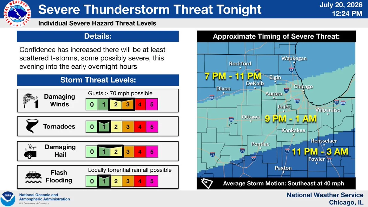
    Here's our latest thinking and timing for tonight's storms. Storms will track NW to SE around 40mph, reaching IL/WI border this evening, continuing into northern IL and NW IN tonight. Damaging winds, are the primary threat, though hail is also possible. #ILwx #INwx
    Headline: Severe T-storm Threat Tonight.  Sub Headline: Individual Severe Hazard Threat Levels.  Gusts ≥ 70 mph possible.  Damaging Winds.  Tornadoes.  Flash Flooding.  Locally torrential rainfall possible.  Details: Confidence has increased there will be at least scattered t-storms, some possibly severe, this evening into the early overnight hours.  Storm Threat Levels: Approximate Timing of Severe Threat: Damaging Hail.    Graphic Created: Monday, July 20, 2026 12:19 PM CDT
    29K029K
  • user avatar
    NWS Chicago
    @NWSChicago
    Jul 20
    Severe thunderstorms will be possible this evening and tonight. The biggest concern is damaging winds, although all severe hazards are possible including tornadoes, damaging hail, and flash flooding. Be sure to have ways to receive warnings if storms occur overnight. (🧵1/4)
    Headline: Severe T-storm Threat Tonight.  Details: Scattered severe thunderstorms will be possible this evening and tonight. The biggest concern is damaging winds, although all severe hazards are possible including tornadoes, damaging hail, and flash flooding. Be sure to have ways to receive warnings if severe weather threatens your area overnight.  Graphic Created: Monday, July 20, 2026 2:51 AM CDT
    28K028K
    user avatar
    NWS Chicago
    @NWSChicago
    Jul 20
    Replying to @NWSChicago
    Air Quality Alerts remain in effect across our area due to wildfire smoke. Visit AirNow.gov for real-time air quality reports. #ILwx #INwx (🧵3/4)
    Image
    6.4K06.4K
    user avatar
    NWS Chicago
    @NWSChicago
    Jul 20
    Scattered storms are possible this evening and overnight, some of which may be strong to severe. Middle and upper 80s are expected today and tomorrow before a dry and slightly cooler pattern takes hold later in the week. #ILwx #INwx (🧵4/4)
    This is a multiday forecast graphic for northern Illinois and northwest Indiana.  Headline: The Week Ahead.  Sub Headline: Chance for scattered severe storms tonight, then turning slightly cooler later in the week.  Visit weather.gov/Chicago for more forecast details for your location.    Graphic Created: Monday, July 20, 2026 2:51 AM CDT
    5.5K05.5K
  • user avatar
    NWS Chicago
    @NWSChicago
    Jul 19
    (🧵1/3) Air Quality Alerts remain in effect across our area due to wildfire smoke through Monday. Visit AirNow.gov for real-time air quality reports. #ILwx #INwx
    Headline: Unhealthy Air Quality Continues.  Sub Headline: Wildfire smoke will continue through Monday, especially early Monday.  What To Expect.  Unhealthy Air Quality Due to wildfire Smoke. When: Through Monday. Where: Areawide. Air Pollution Action Day declared by Illinois EPA.  Air Quality Action Day for NW Indiana declared by IDEM. What To Do.  Reduce long or intense outdoor activities and take more frequent breaks. Check real-time air quality at AirNow.gov   Graphic Created: Sunday, July 19, 2026 3:21 PM CDT
    16K016K
    user avatar
    NWS Chicago
    @NWSChicago
    Jul 19
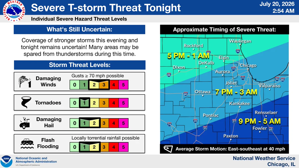
    (🧵2/3) Severe storms are possible early Mon eve into the overnight hours. Damaging winds are the main threat, but locally torrential rainfall may result in an isolated flash flood threat. Its possible the region could dodge the storms, so stay tuned for updates! #ILwx #INwx
    Headline: Severe T-storm Threat Monday Night.  Sub Headline: Individual Severe Hazard Threat Levels.  Storm Threat Levels: Level 2-3 of 5 threat for Damaging Winds, Gusts ≥ 70 mph possible. Level 1 of 5 risk for Tornadoes, Brief tornadoes possible.  Level 1-2 of 4 risk for Flash Flooding, locally torrential rainfall possible. What's Still Uncertain: Coverage of storms across northern IL and northwest IN still uncertain. It is still possible that many areas dodge bad storms Monday night! Approximate Time Window of Severe Threat: Areas near and north of I-88: 5 PM to 1 AM, Areas between I-88 and the Kankakee River, 7 PM to 3 PM, Areas south of the Kankakee River 9 PM to 5 AM. Graphic Created: Sunday, July 19, 2026 3:21 PM CDT
    8.4K08.4K
    user avatar
    NWS Chicago
    @NWSChicago
    Jul 19
    (🧵3/3) After the poor air quality and storms exit Monday night, cooler and less humid conditions are expected through weeks end. Though, breezy winds behind the cold front will large waves and dangerous rip currents at area beaches Tuesday Night through Wednesday! #ILwx #INwx
    This is a multiday forecast graphic for northern Illinois and northwest Indiana.  Headline: Four Day Outlook.  Sub Headline: Period of Cooler Temperature Expected through the Week.  Visit weather.gov/Chicago for more forecast details for your location. Graphic Created: Sunday, July 19, 2026 3:21 PM CDT
    5.5K05.5K
  • user avatar
    NWS Chicago
    @NWSChicago
    Jul 19
    Conditions continue to look favorable for severe storms Monday evening. However, there are still details to be ironed out including whether storms in the morning displace the evening threat elsewhere. Stay up to date on the forecast! #ILwx #INwx
    Headline: Severe Storm Threat Monday Evening.  Sub Headline: What we Know: Conditions will be favorable for severe storms in the region Monday evening. Damaging winds and flash flooding would be the primary hazards locally. What's Still Uncertain: The potential for, and later impacts of, morning thunderstorms. Morning storms may displace the evening threat elsewhere. What to Do: Stay up to date on the forecast and follow trusted sources for weather information.   Graphic Created: Sunday, July 19, 2026 3:28 AM CDT
    13K013K
  • user avatar
    NWS Chicago
    @NWSChicago
    Jul 19
    After a hot stretch of days, temperatures will settle closer to the average for this time of year through much of the week. The next chance of rain will arrive on Monday. #ILwx #INwx
    This is a multiday forecast graphic for northern Illinois and northwest Indiana.  Headline: Five Day Forecast.  Sub Headline: Period of Cooler Temperature Expected through the Week.  Visit weather.gov/Chicago for more forecast details for your location.    Graphic Created: Sunday, July 19, 2026 3:28 AM CDT
    12K012K
  • user avatar
    NWS Chicago
    @NWSChicago
    Jul 19
    Air Quality Alerts remain in effect across our area due to wildfire smoke. Visit AirNow.gov for real-time air quality reports. #ILwx #INwx
    Headline: Unhealthy Air Quality Continues.  Sub Headline: Areas of wildfire smoke continue to move across the region.  What To Expect.  Air Pollution Action Day declared by Illinois EPA.  Air Quality Action Day for NW Indiana declared by IDEM.  Unhealthy Air Quality.  Due to wildfire smoke.  Through Monday.  Areawide.  What To Do.  Reduce long or intense outdoor activities and take more frequent breaks. Check real-time air quality at AirNow.gov   Graphic Created: Sunday, July 19, 2026 3:29 AM CDT
    13K013K
  • user avatar
    NWS Chicago
    @NWSChicago
    Jul 18
    Unhealthy air quality is expected through Monday for all of northern Illinois and northwest Indiana due to wildfire smoke. Avoid long or intense outdoor activities or consider rescheduling or moving activities indoors, especially those with pre-existing health conditions.
    Headline: Unhealthy Air Quality Through Monday.  Sub Headline: What To Expect.  Air Pollution Action Day declared by Illinois EPA.  Air Quality Action Day for NW Indiana declared by IDEM.  Unhealthy Air Quality.  Due to wildfire smoke returning to the region.  Developing this evening and continuing through Monday.  Areawide.  What To Do.  Reduce long or intense outdoor activities and take more frequent breaks. Sensitive Groups: Avoid long or intense outdoor activities or consider rescheduling or moving activities indoors. Visit weather.gov/chicago for the latest forecast updates.   Graphic Created: Saturday, July 18, 2026 5:33 PM CDT
    24K024K
    user avatar
    NWS Chicago
    @NWSChicago
    Jul 19
    [9:18pm CDT 7/18] As anticipated, the smoke plume has moved back into the area, with 3-6 mi. visibility in much of NE #ILwx and NW #INwx at this time, & air quality trending downward. @ILEPA Illinois AQI: airnow.gov/state/?name=il… @idemnews Indiana AQI: airnow.gov/state/?name=in…
    6.3K06.3K
    user avatar
    NWS Chicago
    @NWSChicago
    Jul 19
    In addition, hazardous conditions are expected at the lakeshore tonight into Sunday AM. Beach Hazards Statement in effect until 10 AM Sun for large waves up to 4-7 feet and dangerous, potentially life-threatening currents. #LakeMichigan Beach Forecast: weather.gov/greatlakes/bea…
    5.7K05.7K
  • user avatar
    NWS Chicago
    @NWSChicago
    Jul 18
    The threat of isolated thunderstorms near and south of the Highway 24 corridor will end early this evening. A stronger storm or two may still produce cloud to ground lightning, torrential downpours, and perhaps some locally gusty winds. Storms should end by 8 PM.
    Headline: Isolated T-storms Ending Early Evening.  Sub Headline: Graphic valid through 8:00 PM CDT  7/18/2026 What To Expect.  Isolated thunderstorms ending early this evening.  The strongest storms may produce: Torrential Downpours.  Cloud-to-Ground Lightning.  Threat Area Through 8 PM.  Gusty Winds.    Graphic Created: Saturday, July 18, 2026 5:59 PM CDT
    12K012K
Advertisement
Advertisement