1. X
  2. NWS Fort Worth
Log inSign up
NWS Fort Worth
51.8K posts
Image
user avatar
NWS Fort Worth
@NWSFortWorth
Official X account for the National Weather Service Fort Worth. Details: weather.gov/nws_x
Fort Worth, Texas
weather.gov/fortworth
Joined May 2012
225
Following
189.8K
Followers
RepliesRepliesMediaMedia

New to X?

Sign up now to get your own personalized timeline!

Create account

By signing up, you agree to the Terms of Service and Privacy Policy, including Cookie Use.

Terms·Privacy·Cookies·Accessibility·Ads Info·© 2026 X Corp.
Don't miss what's happening
People on X are the first to know.
Log inSign up
  • user avatar
    NWS Fort Worth
    @NWSFortWorth
    11h
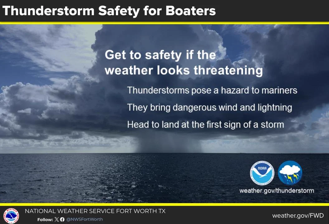
    Boaters: When storms start to form, head to port or safe shelter immediately! weather.gov/safety/safeboa… #WeatherReady
    Get to safety if the weather looks threatening. Thunderstorms pose a hazard to mariners. They bring dangerous wind and lightning. Head to land at the first sign of a storm.
    4.5K04.5K
  • user avatar
    NWS Fort Worth
    @NWSFortWorth
    12h
    The summer heat will intensify this week as high pressure builds over the southern U.S. Afternoon highs will be in the upper 90s to 100s with heat index values upwards of 110 degrees for a few days. Ensure you take all necessary precautions to protect yourself from the heat!
    The summer heat will intensify this week as high pressure builds over the southern U.S. Afternoon highs will be in the upper 90s to 100s with heat index values upwards of 110 degrees for a few days. Ensure you take all necessary precautions to protect yourself from the heat!
    8.5K08.5K
  • user avatar
    NWS Fort Worth
    @NWSFortWorth
    22h
    Today will be the last day with rain chances for a while as a couple stray showers or storms will be possible (10-15% chance) for portions of North Texas and the Big Country. Temps will be near average today with highs mostly in the mid and upper-90s.
    A graphic showing temperatures and rain chances today and tonight across North and Central Texas.
    7.9K07.9K
  • user avatar
    NWS Fort Worth
    @NWSFortWorth
    22h
    An extended period of above normal temperatures is expected the rest of July. This week looks to be the hottest of the summer by far with afternoon highs ranging from 100° to 105°! Be sure to have ways to stay cool and protect yourself from the sun if you plan on being outdoors!
    A graphic showing temperatures across North and Central Texas Monday through Friday this week. There is a climate outlook for temperatures and precipitation on the left valid for the week after next.
    8.1K08.1K
  • user avatar
    NWS Fort Worth
    @NWSFortWorth
    Jul 18
    More summer-like conditions will continue tomorrow with highs in the mid to upper 90s and heat index values from 96 to near 105 degrees. Stay hydrated and make sure to take breaks in the shade or A/C. #dfwwc #ctxwx
    A graphic showing the high temperatures for towns and cities across North and Central Texas for tonight and Sunday.
    5K05K
  • user avatar
    NWS Fort Worth
    @NWSFortWorth
    Jul 18
    More typical summer-like conditions will return to the region this weekend as high pressure builds across much of Texas. Though it will be hot with highs in the 90s, temperatures will still be near or slightly below average this weekend.
    A graphic showing the high temperatures for towns and cities across North and Central Texas Saturday and Sunday.
    7.4K07.4K
  • user avatar
    NWS Fort Worth
    @NWSFortWorth
    Jul 18
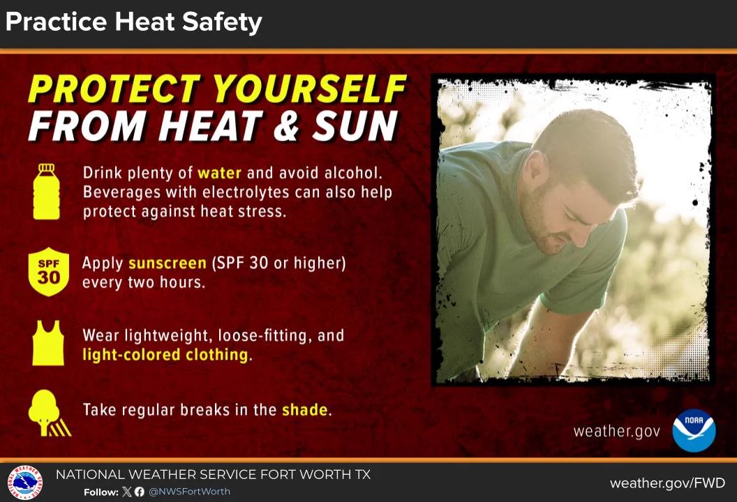
    With very hot temperatures on the horizon for those of us in North and Central Texas, take time to review ways to protect yourself from heat and sun should you need to be outside during the afternoon and evening hours this upcoming week. #summer #heat #txwx #dfwwx
    An infographic showing ways to protect yourself from the heat and sun.
    6.6K06.6K
  • user avatar
    NWS Fort Worth
    @NWSFortWorth
    Jul 18
    With strong high pressure building across Texas, next week may be the hottest week of the summer by far! Most of us will see highs near or just above 100 degrees. Be sure to stay hydrated, wear sunscreen, and have ways to cool off if you have outdoor plans next week! #heat #txwx
    A 4-day forecast of high and low temperatures and peak heat indices for cities across North and Central Texas this upcoming Monday through Thursday.
    6.4K06.4K
  • user avatar
    NWS Fort Worth
    @NWSFortWorth
    Jul 17
    Even if you're not ready for the heat to come back.. it's coming... Triple digit highs by early next week 🥵 #dfwwx #ctxwx
    Image
    Image
    user avatar
    NWS Fort Worth
    @NWSFortWorth
    Jul 17
    Who's ready for a return to hot and dry weather?
    12K012K
  • user avatar
    NWS Fort Worth
    @NWSFortWorth
    Jul 17
    Who's ready for a return to hot and dry weather?
    Yes please16.8%
    No way more rain & clouds83.2%
    161 votesFinal results
    15K015K
  • user avatar
    NWS Fort Worth
    @NWSFortWorth
    Jul 17
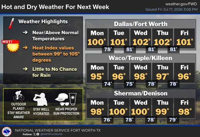
    Seasonably hot and rain-free weather will resume this weekend into next week. Temperatures will return to near or above normal during this time period, with heat index values in the triple-digits through most of next week. #dfwwx #ctxwx #txwx
    Image
    5.6K05.6K
  • user avatar
    NWS Fort Worth
    @NWSFortWorth
    Jul 17
    Isolated to scattered showers and storms will linger across parts of North Texas along/west of Hwy 281 through at least midday today. Temperatures will gradually warm back into the mid 90s by the weekend. #dfwwx #ctxwx #txwx
    Image
    7.9K07.9K
  • user avatar
    NWS Fort Worth
    @NWSFortWorth
    Jul 16
    A few showers/storms may linger tonight and tomorrow, but most of us will dry out with warmer weather expected on Friday through the weekend. We're looking at highs back to the mid/upper 90s to near 100 degrees by late weekend into next week. The TX heat is back!🥵 #dfwwx #ctxwx
    Image
    Image
    8.1K08.1K
  • user avatar
    NWS Fort Worth
    @NWSFortWorth
    Jul 16
    Rain chances will taper off by this weekend, with seasonably hot and rain-free weather prevailing into next week. High temperatures will return to the upper 90s and triple-digits.
    Image
    7.4K07.4K
Advertisement
Advertisement