1. X
  2. NWS GSP
Log inSign up
NWS GSP
54.2K posts
Image
user avatar
NWS GSP
@NWSGSP
Official X Account for National Weather Service Greenville-Spartanburg, SC. Details: weather.gov/nws_x.
Greer, SC
weather.gov/gsp/
Joined June 2012
462
Following
36.5K
Followers
RepliesRepliesMediaMedia

New to X?

Sign up now to get your own personalized timeline!

Create account

By signing up, you agree to the Terms of Service and Privacy Policy, including Cookie Use.

Terms·Privacy·Cookies·Accessibility·Ads Info·© 2026 X Corp.
Don't miss what's happening
People on X are the first to know.
Log inSign up
  • user avatar
    NWS GSP
    @NWSGSP
    2h
    A special weather statement has been issued for Mount Pleasant NC until 10:15 PM EDT
    This graphic displays a special weather statement plotted on a map. The statement is in effect until 10:15 PM EDT.  The statement includes Mount Pleasant NC.  A STRONG THUNDERSTORM WILL IMPACT NORTHEASTERN CABARRUS COUNTY THROUGH 1015 PM EDT. The threats associated with this storm are wind gusts up to 40 MPH and no hail is expected. Seek shelter in a sturdy structure until the storm passes.
    8480848
  • user avatar
    NWS GSP
    @NWSGSP
    2h
    A special weather statement has been issued for Concord NC and Mount Pleasant NC until 9:45 PM EDT
    This graphic displays a special weather statement plotted on a map. The statement is in effect until 9:45 PM EDT.  The statement includes Concord NC and  Mount Pleasant NC.  A STRONG THUNDERSTORM WILL IMPACT NORTHEASTERN CABARRUS COUNTY THROUGH 945 PM EDT. The threats associated with this storm are wind gusts up to 40 MPH and no hail is expected. Seek shelter in a sturdy structure until the storm passes.
    1K01K
  • user avatar
    NWS GSP
    @NWSGSP
    4h
    TThe severe threat returns again on both Tuesday and Wednesday but confidence on isolated severe storms developing on Tuesday is low. Confidence is higher regarding the isolated severe threat on Wednesday as a cold front tracks across the region. #ncwx #scwx #gawx
    Graphic showing the severe weather potential for Tuesday and Wednesday. Isolated strong to severe thunderstorms are possible during the afternoon and evening on Tuesday but confidence is low. Confidence is higher on isolated severe storms developing on Wednesday ahead of a cold front. The main hazard with any severe storms that develop are damaging wind gusts.
    1.2K01.2K
  • user avatar
    NWS GSP
    @NWSGSP
    4h
    A special weather statement has been issued for Bermuda Run NC, Advance NC and Hillsdale NC until 7:45 PM EDT
    This graphic displays a special weather statement plotted on a map. The statement is in effect until 7:45 PM EDT.  The statement includes Bermuda Run NC, Advance NC and  Hillsdale NC.  A STRONG THUNDERSTORM WILL IMPACT CENTRAL DAVIE COUNTY THROUGH 745 PM EDT. The threats associated with this storm are wind gusts up to 40 MPH and no hail is expected. Seek shelter in a sturdy structure until the storm passes.
    1.1K01.1K
  • user avatar
    NWS GSP
    @NWSGSP
    4h
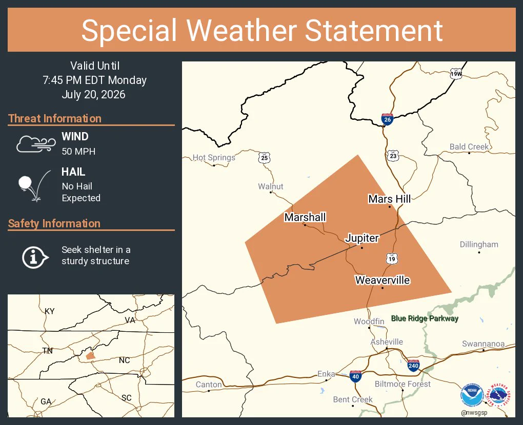
    A special weather statement has been issued for Weaverville NC, Mars Hill NC and Marshall NC until 7:45 PM EDT
    This graphic displays a special weather statement plotted on a map. The statement is in effect until 7:45 PM EDT.  The statement includes Weaverville NC, Mars Hill NC and  Marshall NC.  A STRONG THUNDERSTORM WILL IMPACT SOUTHEASTERN MADISON AND NORTHWESTERN BUNCOMBE COUNTIES THROUGH 745 PM EDT. The threats associated with this storm are wind gusts up to 50 MPH and no hail is expected. Seek shelter in a sturdy structure until the storm passes.
    1.1K01.1K
  • user avatar
    NWS GSP
    @NWSGSP
    4h
    A special weather statement has been issued for Sylva NC, Webster NC and Dillsboro NC until 7:45 PM EDT
    This graphic displays a special weather statement plotted on a map. The statement is in effect until 7:45 PM EDT.  The statement includes Sylva NC, Webster NC and  Dillsboro NC.  A STRONG THUNDERSTORM WILL IMPACT NORTHWESTERN JACKSON COUNTY THROUGH 745 PM EDT. The threats associated with this storm are wind gusts up to 50 MPH and no hail is expected. Seek shelter in a sturdy structure until the storm passes.
    1K01K
  • user avatar
    NWS GSP
    @NWSGSP
    4h
    A special weather statement has been issued for Canton NC, West Canton NC and Cruso NC until 7:30 PM EDT
    This graphic displays a special weather statement plotted on a map. The statement is in effect until 7:30 PM EDT.  The statement includes Canton NC, West Canton NC and  Cruso NC.  The threats associated with this storm are wind gusts up to 40 MPH and no hail is expected. Seek shelter in a sturdy structure until the storm passes.
    1.1K01.1K
  • user avatar
    NWS GSP
    @NWSGSP
    5h
    A special weather statement has been issued for Mocksville NC, Bermuda Run NC and Advance NC until 7:30 PM EDT
    This graphic displays a special weather statement plotted on a map. The statement is in effect until 7:30 PM EDT.  The statement includes Mocksville NC, Bermuda Run NC and  Advance NC.  A STRONG THUNDERSTORM WILL IMPACT DAVIE and NORTHEASTERN IREDELL AND NORTHWESTERN ROWAN COUNTIES THROUGH 730 PM EDT. The threats associated with this storm are wind gusts up to 40 MPH and no hail is expected. Seek shelter in a sturdy structure until the storm passes.
    1.1K01.1K
  • user avatar
    NWS GSP
    @NWSGSP
    5h
    A special weather statement has been issued for Statesville NC and Love Valley NC until 6:45 PM EDT
    This graphic displays a special weather statement plotted on a map. The statement is in effect until 6:45 PM EDT.  The statement includes Statesville NC and  Love Valley NC.  A STRONG THUNDERSTORM WILL IMPACT NORTHERN IREDELL COUNTY THROUGH 645 PM EDT. The threats associated with this storm are wind gusts up to 40 MPH and no hail is expected. Seek shelter in a sturdy structure until the storm passes.
    1K01K
  • user avatar
    NWS GSP
    @NWSGSP
    5h
    A special weather statement has been issued for Burnsville NC, Celo NC and Micaville NC until 6:30 PM EDT
    This graphic displays a special weather statement plotted on a map. The statement is in effect until 6:30 PM EDT.  The statement includes Burnsville NC, Celo NC and  Micaville NC.  A STRONG THUNDERSTORM WILL IMPACT SOUTHEASTERN YANCEY COUNTY THROUGH 630 PM EDT. The threats associated with this storm are wind gusts up to 40 MPH and no hail is expected. Seek shelter in a sturdy structure until the storm passes.
    1.1K01.1K
  • user avatar
    NWS GSP
    @NWSGSP
    6h
    A Flood Advisory is in effect for the following areas through 08:15 PM: Caldwell-NC
    Image
    1.1K01.1K
  • user avatar
    NWS GSP
    @NWSGSP
    6h
    A special weather statement has been issued for Celo NC until 5:45 PM EDT
    This graphic displays a special weather statement plotted on a map. The statement is in effect until 5:45 PM EDT.  The statement includes Celo NC.  A STRONG THUNDERSTORM WILL IMPACT CENTRAL MCDOWELL and SOUTH CENTRAL MITCHELL AND EAST CENTRAL YANCEY COUNTIES THROUGH 545 PM EDT. The threats associated with this storm are wind gusts up to 40 MPH and no hail is expected. Seek shelter in a sturdy structure until the storm passes.
    9640964
  • user avatar
    NWS GSP
    @NWSGSP
    6h
    A special weather statement has been issued for Crossnore NC until 5:45 PM EDT
    This graphic displays a special weather statement plotted on a map. The statement is in effect until 5:45 PM EDT.  The statement includes Crossnore NC.  The threats associated with this storm are wind gusts up to 50 MPH and pea sized hail. Seek shelter in a sturdy structure until the storm passes.
    9720972
  • user avatar
    NWS GSP
    @NWSGSP
    6h
    A tropical system does not have to reach hurricane strength to be deadly. Tropical storms can produce strong winds and tornadoes, as well as heavy rainfall, which can lead to flooding. For more information about tropical storms and hurricanes, visit weather.gov/safety/hurrica…
    Tropical storms can be deadly. Even if it's not a hurricane, tropical storms are still dangerous. They can bring heavy rain, which can lead to deadly flooding. Remain vigilant if a Tropical Storm Watch or Warning is issued for your area. Never walk or drive into floodwaters. It only takes 6 inches of water to knock you over and only 12 inches to sweep a car away.
    9930993
Advertisement
Advertisement