1. X
  2. NWS Houston
Log inSign up
NWS Houston
49.7K posts
Image
user avatar
NWS Houston
@NWSHouston
Official X account for the National Weather Service Houston/Galveston TX. Details: weather.gov/nws_x
Houston, Texas
weather.gov/hgx
Joined June 2012
504
Following
134.2K
Followers
RepliesRepliesMediaMedia

New to X?

Sign up now to get your own personalized timeline!

Create account

By signing up, you agree to the Terms of Service and Privacy Policy, including Cookie Use.

Terms·Privacy·Cookies·Accessibility·Ads Info·© 2026 X Corp.
Don't miss what's happening
People on X are the first to know.
Log inSign up
  • NWS Houston reposted
    user avatar
    National Hurricane Center
    @NHC_Atlantic
    22h
    2 pm EDT July 18 - There is now a medium chance of a tropical depression forming over the Gulf of America. Here are the Key Messages about the system. Visit hurricanes.gov for updates.
    Image
    197K0197K
  • user avatar
    NWS Houston
    @NWSHouston
    Jul 18
    Image
    5.4K05.4K
  • NWS Houston reposted
    user avatar
    National Hurricane Center
    @NHC_Atlantic
    Jul 17
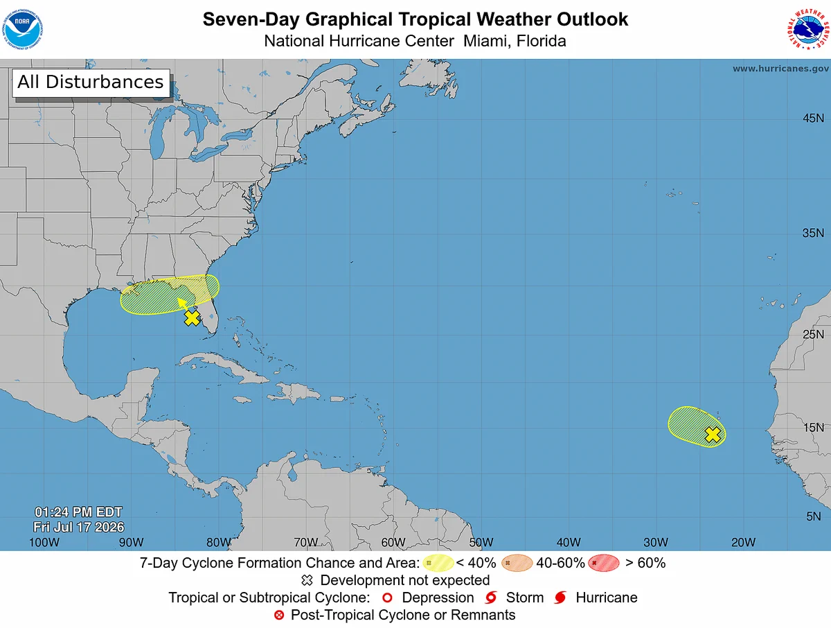
    2 pm EDT - NHC is monitoring an upper-level low over the eastern Gulf. This system has a low chance of tropical development as it meanders northward over the next several days. Visit hurricanes.gov for details.
    Image
    96K096K
  • user avatar
    NWS Houston
    @NWSHouston
    Jul 17
    Isolated to widely scattered showers/thunderstorms today. Rain chances fall while temperatures rise as we head into the weekend. Somewhat hotter than normal conditions possible by next week. #HOUwx #GLSwx
    Image
    Image
    Image
    5.6K05.6K
  • user avatar
    NWS Houston
    @NWSHouston
    Jul 16
    A special weather statement has been issued for Austonio TX until 5:15 PM CDT
    This graphic displays a special weather statement plotted on a map. The statement is in effect until 5:15 PM CDT.  The statement includes Austonio TX.  A STRONG THUNDERSTORM WILL IMPACT NORTHWESTERN HOUSTON COUNTY THROUGH 515 PM CDT. The threats associated with this storm are wind gusts up to 40 MPH and pea sized hail. Seek shelter in a sturdy structure until the storm passes.
    3.8K03.8K
  • user avatar
    NWS Houston
    @NWSHouston
    Jul 15
    Showers and isolated thunderstorms will decrease later this afternoon and evening.
    Image
    00:00
    5.1K05.1K
  • user avatar
    NWS Houston
    @NWSHouston
    Jul 15
    Aviso Especial Marítimo incluye Aguas costeras desde Freeport hasta el Canal de Navegación de Matagorda TX hacia afuera 20 MN y Bahía de Matagorda hasta las 4:00 PM CDT
    Este gráfico muestra la localización en el mapa de un Aviso Especial Marítimo. El aviso estará en efecto hasta las 4:00 PM CDT. El aviso incluye a Aguas costeras desde Freeport hasta el Canal de Navegación de Matagorda TX hacia afuera 20 MN y Bahía de Matagorda. Las amenazas asociadas a este aviso son: ráfagas de vientos de mayor de 34 nudos yno se espera granizo. Las trombas marinas son posibles. Alto oleaje. Busque un puerto seguro y tome medidas de precaución.
    3.5K03.5K
  • user avatar
    NWS Houston
    @NWSHouston
    Jul 15
    Special Marine Warning including the Coastal waters from Freeport to Matagorda Ship Channel TX out 20 NM and Matagorda Bay until 4:00 PM CDT
    This graphic displays a special marine warning plotted on a map. The warning is in effect until 4:00 PM CDT. The warning includes coastal waters from Freeport to Matagorda Ship Channel TX out 20 NM and Matagorda Bay. The threats associated with this warning are wind gusts greater than 34kts and no hail expected.Waterspouts are possible. Steep waves can be expected. Seek safe harbor and take protective actions.
    3.2K03.2K
  • user avatar
    NWS Houston
    @NWSHouston
    Jul 15
    Aviso Especial Marítimo incluye Aguas costeras desde Freeport hasta el Canal de Navegación de Matagorda TX hacia afuera 20 MN y Bahía de Matagorda hasta las 2:30 PM CDT
    Este gráfico muestra la localización en el mapa de un Aviso Especial Marítimo. El aviso estará en efecto hasta las 2:30 PM CDT. El aviso incluye a Aguas costeras desde Freeport hasta el Canal de Navegación de Matagorda TX hacia afuera 20 MN y Bahía de Matagorda. Las amenazas asociadas a este aviso son: ráfagas de vientos de mayor de 40 nudos yno se espera granizo. Las trombas marinas no son esperadas. Alto oleaje. Busque un puerto seguro y tome medidas de precaución.
    4.7K04.7K
  • user avatar
    NWS Houston
    @NWSHouston
    Jul 15
    Special Marine Warning including the Coastal waters from Freeport to Matagorda Ship Channel TX out 20 NM and Matagorda Bay until 2:30 PM CDT
    This graphic displays a special marine warning plotted on a map. The warning is in effect until 2:30 PM CDT. The warning includes coastal waters from Freeport to Matagorda Ship Channel TX out 20 NM and Matagorda Bay. The threats associated with this warning are wind gusts greater than 40kts and no hail expected.Waterspouts are not expected. Steep waves can be expected. Seek safe harbor and take protective actions.
    3K03K
  • user avatar
    NWS Houston
    @NWSHouston
    Jul 15
    Aviso Especial Marítimo incluye Aguas costeras desde High Island hasta Freeport TX hacia afuera 20 MN y Bahía de Galveston hasta la 1:00 PM CDT
    Este gráfico muestra la localización en el mapa de un Aviso Especial Marítimo. El aviso estará en efecto hasta la 1:00 PM CDT. El aviso incluye a Aguas costeras desde High Island hasta Freeport TX hacia afuera 20 MN y Bahía de Galveston. Las amenazas asociadas a este aviso son: ráfagas de vientos de mayor de 34 nudos yno se espera granizo. Las trombas marinas son posibles. Alto oleaje. Busque un puerto seguro y tome medidas de precaución.
    3.3K03.3K
  • user avatar
    NWS Houston
    @NWSHouston
    Jul 15
    Special Marine Warning including the Coastal waters from High Island to Freeport TX out 20 NM and Galveston Bay until 1:00 PM CDT
    This graphic displays a special marine warning plotted on a map. The warning is in effect until 1:00 PM CDT. The warning includes coastal waters from High Island to Freeport TX out 20 NM and Galveston Bay. The threats associated with this warning are wind gusts greater than 34kts and no hail expected.Waterspouts are possible. Steep waves can be expected. Seek safe harbor and take protective actions.
    3.5K03.5K
  • user avatar
    NWS Houston
    @NWSHouston
    Jul 15
    9:00 Radar Update - Locally heavy rainfall is ongoing across much of Jackson, Wharton, and Matagorda Counties. Additional shower and thunderstorm activity is expected across much of southeast Texas later this afternoon. #txwx #houwx #TurnAroundDontDrown
    Image
    00:00
    6.3K06.3K
  • user avatar
    NWS Houston
    @NWSHouston
    Jul 15
    Due to ongoing locally heavy rainfall, the weekly NOAA weather radio test has been postponed to Thursday, 7/16/2026, or the next available fair weather day.
    Image
    3.4K03.4K
Advertisement
Advertisement