1. X
  2. NWS Baltimore-Washington
Log inSign up
NWS Baltimore-Washington
30.3K posts
Image
user avatar
NWS Baltimore-Washington
@NWS_BaltWash
Official X Account for National Weather Service Baltimore/Washington. For NWS Posting Policy, click here: weather.gov/nws_x
Sterling, VA
weather.gov/washington
Joined October 2012
285
Following
80.1K
Followers
RepliesRepliesMediaMedia

New to X?

Sign up now to get your own personalized timeline!

Create account

By signing up, you agree to the Terms of Service and Privacy Policy, including Cookie Use.

Terms·Privacy·Cookies·Accessibility·Ads Info·© 2026 X Corp.
Don't miss what's happening
People on X are the first to know.
Log inSign up
  • user avatar
    NWS Baltimore-Washington
    @NWS_BaltWash
    14h
    Today and Monday will be cooler with lower humidity. Lingering shower/thunderstorm chances will be limited to central Virginia today, eventually returning north late Monday. Severe thunderstorms and locally heavy rainfall are possible Tuesday.
    An infographic shows the forecast for Sunday through Tuesday. High temperatures will be in the 80s to around 90 each day, with 70s in the mountains. An image is included that shows the Baltimore Inner Harbor under mostly sunny skies.
    4.6K04.6K
  • user avatar
    NWS Baltimore-Washington
    @NWS_BaltWash
    22h
    Earlier showers and thunderstorms have moved out of the area. We're watching ongoing thunderstorms across PA. These storms are expected to weaken and eventually dissipate as they move in from the north, with northern MD having the greatest chance for a shower or storm overnight.
    Graphic showing forecast low temperatures tonight. Low temperatures are forecast to be in the upper 60s to mid 70s for most, with low to mid 60s in the Alleghenies.
    6K06K
  • user avatar
    NWS Baltimore-Washington
    @NWS_BaltWash
    Jul 18
    Special Marine Warning including the Chesapeake Bay from Drum Point MD to Smith Point VA, Tangier Sound and the inland waters surrounding Bloodsworth Island, Chesapeake Bay from North Beach to Drum Point MD and Patuxent River to Broomes Island MD until 8:30 PM EDT
    This graphic displays a special marine warning plotted on a map. The warning is in effect until 8:30 PM EDT. The warning includes Chesapeake Bay from Drum Point MD to Smith Point VA, Tangier Sound and the inland waters surrounding Bloodsworth Island, Chesapeake Bay from North Beach to Drum Point MD and Patuxent River to Broomes Island MD. The threats associated with this warning are wind gusts greater than 34kts and no hail expected.Waterspouts are not expected. Steep waves can be expected. Seek safe harbor and take protective actions.
    4.5K04.5K
  • user avatar
    NWS Baltimore-Washington
    @NWS_BaltWash
    Jul 18
    Special Marine Warning continues for the Chesapeake Bay from Drum Point MD to Smith Point VA, Tangier Sound and the inland waters surrounding Bloodsworth Island and Tidal Potomac from Cobb Island MD to Smith Point VA until 7:00 PM EDT
    This graphic displays a special marine warning plotted on a map. The warning is in effect until 7:00 PM EDT. The warning includes Chesapeake Bay from Drum Point MD to Smith Point VA, Tangier Sound and the inland waters surrounding Bloodsworth Island and Tidal Potomac from Cobb Island MD to Smith Point VA. The threats associated with this warning are wind gusts greater than 48kts and no hail expected.Waterspouts are not expected. Steep waves can be expected. Seek safe harbor and take protective actions.
    4.2K04.2K
  • user avatar
    NWS Baltimore-Washington
    @NWS_BaltWash
    Jul 18
    Special Marine Warning including the Chesapeake Bay from Drum Point MD to Smith Point VA, Tangier Sound and the inland waters surrounding Bloodsworth Island, Chesapeake Bay from North Beach to Drum Point MD and Patuxent River to Broomes Island MD until 8:00 PM EDT
    This graphic displays a special marine warning plotted on a map. The warning is in effect until 8:00 PM EDT. The warning includes Chesapeake Bay from Drum Point MD to Smith Point VA, Tangier Sound and the inland waters surrounding Bloodsworth Island, Chesapeake Bay from North Beach to Drum Point MD and Patuxent River to Broomes Island MD. The threats associated with this warning are wind gusts greater than 34kts and no hail expected.Waterspouts are not expected. Steep waves can be expected. Seek safe harbor and take protective actions.
    4.1K04.1K
  • user avatar
    NWS Baltimore-Washington
    @NWS_BaltWash
    Jul 18
    Severe Thunderstorm Warning continues for California MD, Lexington Park MD and Solomons MD until 6:00 PM EDT
    This graphic displays a severe thunderstorm warning plotted on a map. The warning is in effect until 6:00 PM EDT. The warning includes California MD, Lexington Park MD and Solomons MD.  This warning is for Southeastern St. Marys County. The threats associated with this warning are wind gusts up to 60 MPH and quarter sized hail. There are 51,523 people in the warning along with 12 schools and 0 hospitals.
    5K05K
  • user avatar
    NWS Baltimore-Washington
    @NWS_BaltWash
    Jul 18
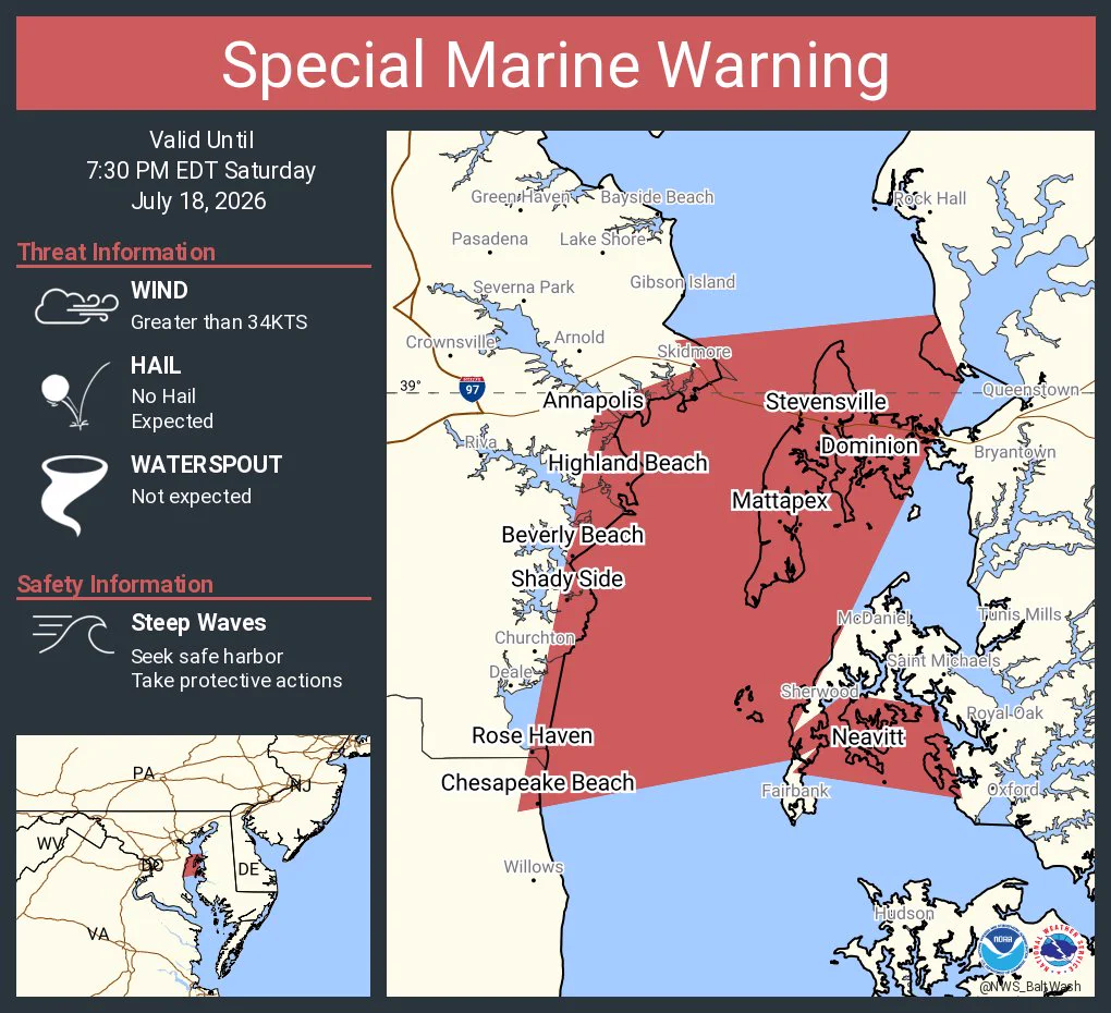
    Special Marine Warning including the Chesapeake Bay from North Beach to Drum Point MD, Chesapeake Bay from Pooles Island to Sandy Point MD, Chesapeake Bay from Sandy Point to North Beach MD and Choptank River to Cambridge MD and the Little Choptank River until 7:30 PM EDT
    This graphic displays a special marine warning plotted on a map. The warning is in effect until 7:30 PM EDT. The warning includes Chesapeake Bay from North Beach to Drum Point MD, Chesapeake Bay from Pooles Island to Sandy Point MD, Chesapeake Bay from Sandy Point to North Beach MD and Choptank River to Cambridge MD and the Little Choptank River. The threats associated with this warning are wind gusts greater than 34kts and no hail expected.Waterspouts are not expected. Steep waves can be expected. Seek safe harbor and take protective actions.
    4K04K
  • user avatar
    NWS Baltimore-Washington
    @NWS_BaltWash
    Jul 18
    Special Marine Warning including the Tidal Potomac from Cobb Island MD to Smith Point VA and Tidal Potomac from Indian Head to Cobb Island MD until 6:30 PM EDT
    This graphic displays a special marine warning plotted on a map. The warning is in effect until 6:30 PM EDT. The warning includes Tidal Potomac from Cobb Island MD to Smith Point VA and Tidal Potomac from Indian Head to Cobb Island MD. The threats associated with this warning are wind gusts greater than 34kts and no hail expected.Waterspouts are not expected. Steep waves can be expected. Seek safe harbor and take protective actions.
    3.8K03.8K
  • user avatar
    NWS Baltimore-Washington
    @NWS_BaltWash
    Jul 18
    Special Marine Warning including the Tidal Potomac from Key Bridge to Indian Head MD until 6:15 PM EDT
    This graphic displays a special marine warning plotted on a map. The warning is in effect until 6:15 PM EDT. The warning includes Tidal Potomac from Key Bridge to Indian Head MD. The threats associated with this warning are wind gusts greater than 34kts and no hail expected.Waterspouts are not expected. Steep waves can be expected. Seek safe harbor and take protective actions.
    4K04K
  • user avatar
    NWS Baltimore-Washington
    @NWS_BaltWash
    Jul 18
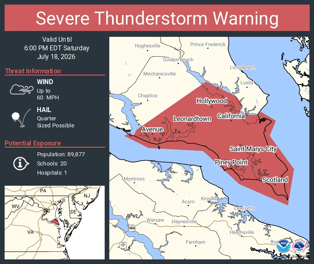
    Severe Thunderstorm Warning including California MD, Lexington Park MD and Leonardtown MD until 6:00 PM EDT
    This graphic displays a severe thunderstorm warning plotted on a map. The warning is in effect until 6:00 PM EDT. The warning includes California MD, Lexington Park MD and Leonardtown MD.  This warning is for St. Marys County in southern Maryland. The threats associated with this warning are wind gusts up to 60 MPH and quarter sized hail. There are 89,877 people in the warning along with 20 schools and 1 hospital.
    3.9K03.9K
  • user avatar
    NWS Baltimore-Washington
    @NWS_BaltWash
    Jul 18
    Special Marine Warning including the Chesapeake Bay from Drum Point MD to Smith Point VA, Tangier Sound and the inland waters surrounding Bloodsworth Island and Tidal Potomac from Cobb Island MD to Smith Point VA until 7:00 PM EDT
    This graphic displays a special marine warning plotted on a map. The warning is in effect until 7:00 PM EDT. The warning includes Chesapeake Bay from Drum Point MD to Smith Point VA, Tangier Sound and the inland waters surrounding Bloodsworth Island and Tidal Potomac from Cobb Island MD to Smith Point VA. The threats associated with this warning are wind gusts greater than 48kts and no hail expected.Waterspouts are not expected. Steep waves can be expected. Seek safe harbor and take protective actions.
    3.9K03.9K
  • user avatar
    NWS Baltimore-Washington
    @NWS_BaltWash
    Jul 18
    Special Marine Warning including the Tidal Potomac from Cobb Island MD to Smith Point VA until 5:45 PM EDT
    This graphic displays a special marine warning plotted on a map. The warning is in effect until 5:45 PM EDT. The warning includes Tidal Potomac from Cobb Island MD to Smith Point VA. The threats associated with this warning are wind gusts greater than 34kts and no hail expected.Waterspouts are not expected. Steep waves can be expected. Seek safe harbor and take protective actions.
    3.8K03.8K
  • user avatar
    NWS Baltimore-Washington
    @NWS_BaltWash
    Jul 18
    Special Marine Warning including the Chesapeake Bay from Pooles Island to Sandy Point MD, Chesapeake Bay from Sandy Point to North Beach MD, Eastern Bay and Chester River to Queenstown MD until 5:45 PM EDT
    This graphic displays a special marine warning plotted on a map. The warning is in effect until 5:45 PM EDT. The warning includes Chesapeake Bay from Pooles Island to Sandy Point MD, Chesapeake Bay from Sandy Point to North Beach MD, Eastern Bay and Chester River to Queenstown MD. The threats associated with this warning are wind gusts greater than 34kts and no hail expected.Waterspouts are not expected. Steep waves can be expected. Seek safe harbor and take protective actions.
    3.7K03.7K
  • user avatar
    NWS Baltimore-Washington
    @NWS_BaltWash
    Jul 18
    Flash Flood Warning continues for Frederick MD, Urbana MD and Braddock Heights MD until 6:15 PM EDT
    This graphic displays a flash flood warning plotted on a map. The warning is in effect until 6:15 PM EDT. The warning includes Frederick MD, Urbana MD and Braddock Heights MD.  This warning is for Southern Frederick County In North Central Maryland. Avoid walking or driving through flood waters! Move immediately to higher ground! There are 165,198 people in the warning along with 33 schools and 1 hospital.
    4K04K
Advertisement
Advertisement