Log inSign up
Missouri State Emergency Management Agency
11.9K posts
Image
user avatar
Missouri State Emergency Management Agency
@MoSEMA_
SEMA's mission is to help our fellow Missourians prepare for, respond to and recover from all emergencies. Account NOT monitored 24/7.
Jefferson City, MO
sema.dps.mo.gov
Joined April 2015
487
Following
16.3K
Followers
  • user avatar
    Missouri State Emergency Management Agency
    @MoSEMA_
    Jun 18
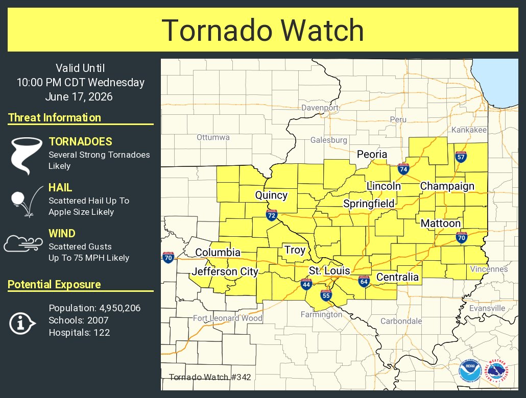
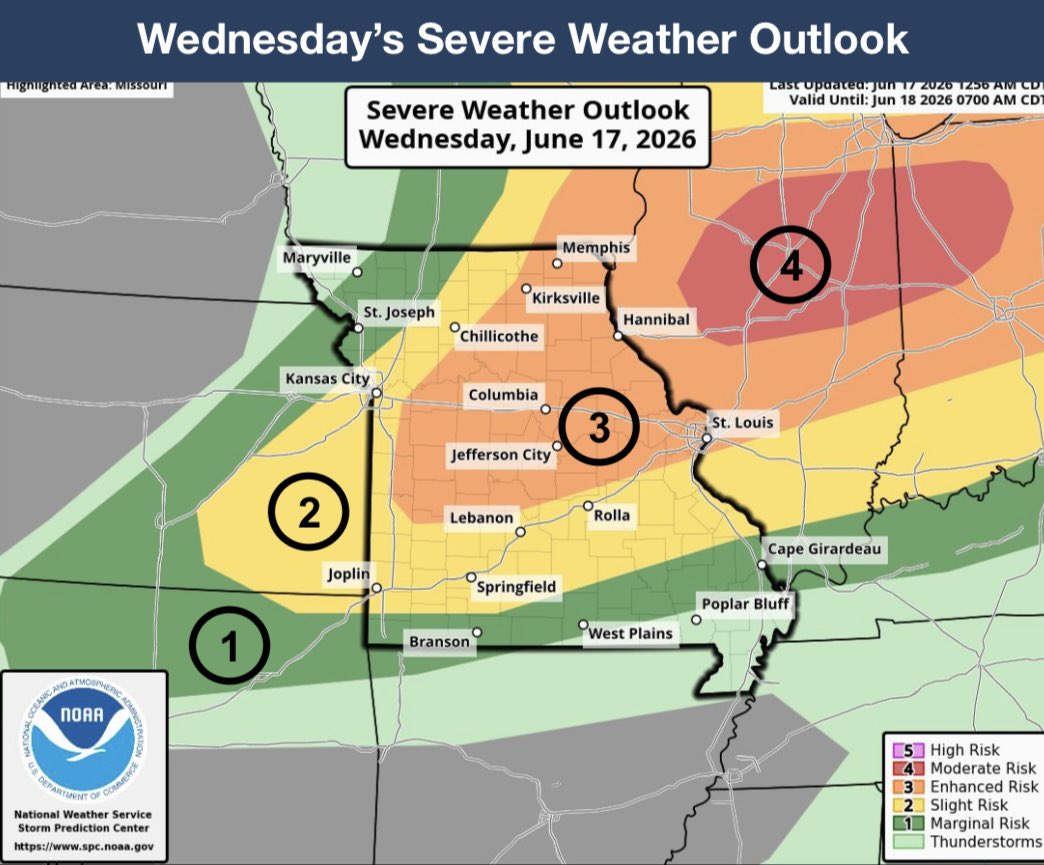
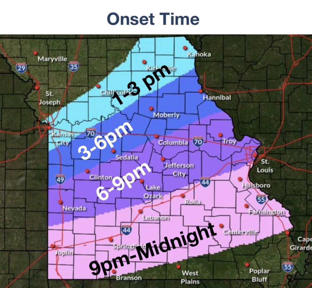
    We appreciate the full support of @GovMikeKehoe's administration throughout the planning for and now the operations to make @FWC26KansasCity a success for fans, players and visitors from around the world. The same type of teamwork, training and practice that is taking place on
    user avatar
    Governor Mike Kehoe
    @GovMikeKehoe
    Jun 18
    Proud to see the work of @FWC26KansasCity organizers with local, state, and federal public safety and emergency management officials firsthand alongside @WHTaskForceFIFA Executive Director Andrew Giuliani. We appreciate the continued efforts by many to support a safe, secure,
    Image
    Image
    Image
    Image
    1.3K
  • Missouri State Emergency Management Agency reposted
    user avatar
    NWS St. Louis
    @NWSStLouis
    Jun 17
    A tornado watch has been issued for parts of Illinois and Missouri until 10 PM CDT
    This graphic displays Tornado Watch watch number 342 plotted on a map. The watch is in effect until 10:00 PM CDT. The watch includes parts of Illinois and Missouri. The threats associated with this watch are several strong tornadoes likely, scattered hail up to apple size likely and scattered gusts up to 75 mph likely. There are 4,950,206 people in the watch along with 2007 schools and 122 hospitals.
    5K
  • user avatar
    Missouri State Emergency Management Agency
    @MoSEMA_
    Jun 17
    Strong winds may be headed your way as well with some gusts expected to be up to 45-50 mph ahead of potential severe thunderstorms. Bring in loose outdoor objects & drive cautiously today during your commute.
    user avatar
    NWS St. Louis
    @NWSStLouis
    Jun 17
    Strong southwesterly winds will gust up to 45 to 50 mph today ahead of potential severe thunderstorms along cold front that will move across the area late today and tonight. Bring in loose outdoor objects and drive cautiously today. #stlwx #midmowx #mowx #ilwx
    There is a map of the wind advisory highlighted in brown over eastern Missouri and southwest Illinois.
    932
  • user avatar
    Missouri State Emergency Management Agency
    @MoSEMA_
    Jun 17
    ‼️ TODAY’S ENHANCED RISK (3 of 5) ‼️ Showers & thunderstorms will move across parts of northern MO this morning with a low chance for a severe thunderstorms over NE MO. ● A cold front will drop through the area through tonight, bringing showers & thunderstorms to the region. ●
    Image
    Image
    1.1K
  • Missouri State Emergency Management Agency reposted
    user avatar
    FIFA World Cup 26 Kansas City
    @FWC26KansasCity
    Jun 17
    We are aware of delays affecting some transport services across the network. We are working with our transport partners to restore normal operations as quickly as possible, ensuring the safe passage of all attending fans. #FIFAWorldCup #WeAreKansasCity
    Image
    27K
  • Missouri State Emergency Management Agency reposted
    user avatar
    NWS Kansas City
    @NWSKansasCity
    Jun 16
    Severe storms are possible Wednesday from 3-8 PM. All severe hazards—large hail, damaging winds, and a few tornadoes—are possible. Strong SW wind gusts up to 50 MPH are also expected Wednesday morning through early afternoon. Stay weather aware! #mowx #kswx
    National Weather Service Kansas City, MO graphic titled "Severe Weather Potential Tomorrow" dated June 16, 2026. Key messages state severe storms are possible Wednesday from 3 to 8 PM, with large hail, damaging winds, and a few tornadoes possible. Strong southwest winds are expected Wednesday 7 AM through early afternoon with gusts up to 50 MPH. Additional chances for showers and thunderstorms are noted for the weekend, with severe storms and flooding rainfall possible. A Severe Weather Outlook map for Wednesday, June 17, 2026, shows a Marginal Risk (Level 1) over St. Joseph and Maryville; a Slight Risk (Level 2) covering Kansas City, Topeka, and Warrensburg; and an Enhanced Risk (Level 3) across central and northeastern Missouri, including Chillicothe, Moberly, Columbia, and Sedalia.
    11K
  • user avatar
    Missouri State Emergency Management Agency
    @MoSEMA_
    Jun 16
    Commonly accepted misconceptions about tornadoes often lead people to make mistakes when preparing for severe weather. Read up on more myths & check out the videos on how to stay safe no matter where you are at StormAware.mo.gov. #MoWx
    Image
    415
  • user avatar
    Missouri State Emergency Management Agency
    @MoSEMA_
    Jun 16
    Heads up on tomorrow’s severe weather from @MoPublicSafety. Pay attention to the local forecast & plan ahead on how to stay safe if your area is impacted. #StormAware
    Image
    850
  • Missouri State Emergency Management Agency reposted
    user avatar
    MoDOT
    @MoDOT
    Jun 15
    If you're planning to attend any of the FIFA World Cup games, events or activities, be sure to allow yourself plenty of time to get where you need to go. Slow down in work zones, watch for pedestrians, drive sober and focus your attention on the road. 📱👇⚽🚶‍♂️
    Image
    1.7K
  • Missouri State Emergency Management Agency reposted
    user avatar
    Governor Mike Kehoe
    @GovMikeKehoe
    Jun 14
    Our hearts go out those who lost loved ones in today’s tragic crash of a skydiving plane near Butler Memorial Airport. @MSHPTrooperA has been on scene assisting local authorities since the immediate aftermath of the crash. The Patrol will continue to assist for as long as its
    5.2K
  • Missouri State Emergency Management Agency reposted
    user avatar
    MoDOT
    @MoDOT
    Jun 13
    ST. LOUIS ALERT:
    user avatar
    MoDOT St. Louis Area
    @MoDOT_StLouis
    Jun 13
    ST. LOUIS- MoDOT is monitoring the situation regarding a sinkhole that developed on North Broadway under Interstate 44 in the City of St. Louis. The sinkhole has exposed  bridge footings on the I-44 bridges over Broadway.
    Image
    3.2K
  • user avatar
    Missouri State Emergency Management Agency
    @MoSEMA_
    Jun 13
    Q: What’s the difference between a WATCH & WARNING? A: “Tornado Watch” means the ingredients could potentially lead to a tornado and a “Tornado Warning” means it's been physically spotted or indicated by radar. This graphic is a great visual representation of the comparison,
    Image
    This graphic displays Tornado Watch watch number 327 plotted on a map. The watch is in effect until 11:00 PM CDT. The watch includes parts of Kansas and Missouri. The threats associated with this watch are a couple tornadoes possible, scattered hail up to tennis ball size likely and scattered gusts up to 75 mph likely. There are 2,978,204 people in the watch along with 1157 schools and 95 hospitals.
    user avatar
    NWS Kansas City
    @NWSKansasCity
    Jun 13
    A tornado watch has been issued for parts of Kansas and Missouri until 11 PM CDT
    743
  • user avatar
    Missouri State Emergency Management Agency
    @MoSEMA_
    Jun 13
    🛣️ More than 50 roads in Missouri are currently closed due to flooding. ⚠️ Today’s severe weather may produce more locally heavy rainfall & isolated flash flooding, particularly in locations receiving multiple rounds of storms. 🛑 NEVER be tempted to drive into floodwater
    Image
    1.8K

New to X?

Sign up now to get your own personalized timeline!

Create account

By signing up, you agree to the Terms of Service and Privacy Policy, including Cookie Use.

Terms·Privacy·Cookies·Accessibility·Ads Info·© 2026 X Corp.
Don't miss what's happening
People on X are the first to know.
Log inSign up
Advertisement
Advertisement