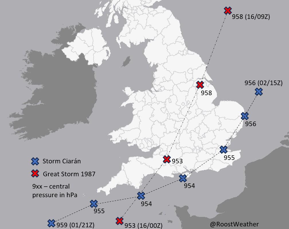
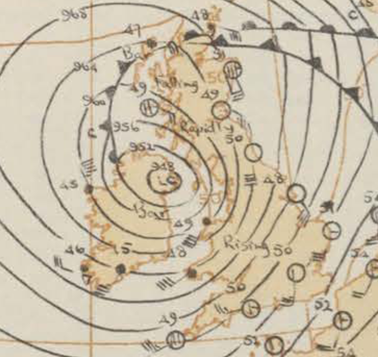
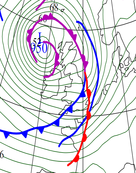
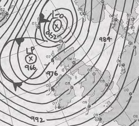
Log inSign up
Dan Harris
14.4K posts
Image
user avatar
Dan Harris
@RoostWeather
Chief Meteorologist @metoffice. FRMetS, CMet, Roostmaster. @RMetS 'Weather' News co-editor. World famous speedcuber. Personal account, views my own.
Mid Devon
roostweather.com
Joined May 2021
258
Following
3,750
Followers
  • Pinned
    user avatar
    Dan Harris
    @RoostWeather
    Jan 19
    Replying to @RoostWeather
    I'm also going to be leaving Twitter soon and posting solely on BlueSky @RoostWeather.bsky.social If you want to get in touch feel free to message me there, or contact me via the form on my page - roostweather.com/contact.php I'm slowly getting round to my correspondence! (4/4)
    Image
    1.3K
  • user avatar
    Dan Harris
    @RoostWeather
    Sep 5, 2021
    #Larry from @Windycom
    Image
  • user avatar
    Dan Harris
    @RoostWeather
    Jul 9, 2022
    GFS 06Z run producing 42-43ºC as a maximum #temperature for the 17th July... here's some points of interest from a meteorological, and climatological point of view...
    Image
  • user avatar
    Dan Harris
    @RoostWeather
    Nov 9, 2023
    Comparison of #StormCiaran vs the 1987 "Great Storm". Similar central pressure, but Oct 87 moved faster, had slightly stronger winds, and a more northerly track, bringing them across SE UK. Most similar for NW #France and #Jersey (85-95kn at 5000' in Ciaran, vs 100 kn in 1987).
    Image
    31K
  • user avatar
    Dan Harris
    @RoostWeather
    Oct 29, 2023
    Some extreme low pressure solutions showing up next Thurs, eg 28/12Z MO GM at 949hPa at 06Z This would challenge November #UK records, 948.4hPa at #Aldergrove on 06Z 30/11/1954 the lowest currently in the MIDAS dataset Other notable lows - 949.3 (11/11/10), 950.4 (13/11/91)
    Image
    Image
    Image
    Image
    44K
  • user avatar
    Dan Harris
    @RoostWeather
    Aug 24, 2025
    Around 1000km across, ex-#HurricaneErin is comparable in size to the UK, as it's extratropical development phase comes to an end. Fantastic imagery courtesy of #eumetsat
    Image
    7K
  • user avatar
    Dan Harris
    @RoostWeather
    Jul 16, 2023
    Must be a Sunday #NightShift - time to draw the charts...
    Image
    12K
  • user avatar
    Dan Harris
    @RoostWeather
    Apr 6, 2022
    I've built a page which allows you to look back at previous runs, to help more easily identify model trends. Check it out here - roostweather.com/models/model_t… An explanation of how it works is available on the left of the page. Thanks to @wxcharts for allowing me to use their images.
    Image
  • user avatar
    Dan Harris
    @RoostWeather
    Dec 24, 2022
    A special #Christmas chart/card for all my followers... a non traditional frontal analysis but a festive one nonetheless. It's been great to have been part of the community and to share weather facts and stats with you all over this past year. Have a great Christmas everyone!
    Image
    6.5K
  • user avatar
    Dan Harris
    @RoostWeather
    Aug 2, 2023
    With a reading of 983.0hPa on the 1300Z ob, @RNASYeovilton has recorded its lowest August mean sea level pressure since its record began in 1965. Previous lowest was 983.8hPa at 0700Z on Aug 30 1992. 983.9hPa the low at the Roost!
    Image
    15K
  • user avatar
    Dan Harris
    @RoostWeather
    Oct 20, 2023
    Probably post night shift tiredness talking, and to no-one in particular, but: The Met Office don't issue medium or high impact warnings lightly. If we go RED, it comes from the culmination of intense analysis/discussion between experts in the field Take them seriously, please.
    Image
    11K
  • user avatar
    Dan Harris
    @RoostWeather
    Jan 16, 2022
    This is an absolutely stunning visualisation of the shockwave crossing the UK, thanks so much @imthursty. @burgwx
    user avatar
    Will Thurston
    @imthursty
    Jan 16, 2022
    Shockwave from Hunga Tonga-Hunga Haʻapai eruption plume, seen by pressure change at UK sites. Wave moves southward down the country 18-20Z 15Jan. The same wave, but travelling the other way around the globe, moves northward up the country 01-03Z 16Jan. @RoostWeather @Silkstiniho
    Image
    00:00
  • user avatar
    Dan Harris
    @RoostWeather
    Sep 30, 2025
    "Hurricane #Humberto to batter Britain"... not quite as simple as that. Notwithstanding if it were to reach the UK it would be Ex-Humberto, the deep low that arrives at the weekend may contain some portion of Humberto but actually spawn from a completely different initial low.
    Image
    7.6K
  • user avatar
    Dan Harris
    @RoostWeather
    Sep 26, 2023
    Wow it's even better now, a wonderful example of Shapiro-Keyser cyclogenesis - #StormAgnes There must be a sting-jet occurring, with prominent striations at the tip of the cloud head. I have a vague idea they might be called "Scorer's fingers" - though I can't find a source.
    Image
    25K

New to X?

Sign up now to get your own personalized timeline!

Create account

By signing up, you agree to the Terms of Service and Privacy Policy, including Cookie Use.

Terms·Privacy·Cookies·Accessibility·Ads Info·© 2026 X Corp.
Don't miss what's happening
People on X are the first to know.
Log inSign up
Advertisement
Advertisement