Log inSign up
NASA Earth
NASA
25K posts
NASA Earth profile banner
@NASAEarth

NASA Earth

NASA
@NASAEarth
NASA’s favorite (habitable) planet. 🌎💚 Studying Earth from ground to orbit.
Earth
science.nasa.gov/earth/
Joined March 2009
86
Following
3.7M
Followers
RepliesRepliesRepostsRepostsMediaMedia

Log in or sign up for X

See what’s happening and join the conversation

Continue with phone
or
Log in with username or email
Terms·Privacy·Cookies·Accessibility·Ads Info·© 2026 X Corp.
  • @NASAEarth
    NASA Earth
    NASA
    @NASAEarth
    Sep 3
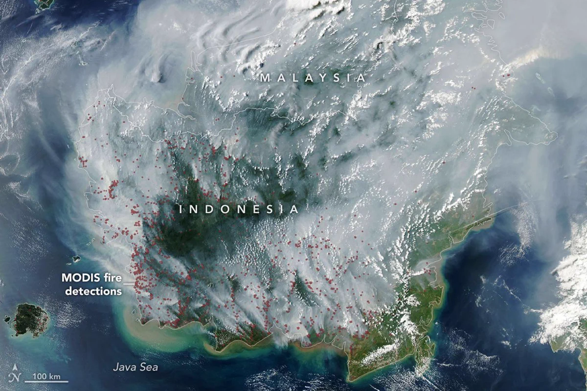
    Fires are smoldering in Indonesia, which is in a severe and widespread drought. Some of these are tropical peatland fires, which burn slowly, release higher amounts of air pollution, and are notoriously difficult to extinguish.
    NASA satellite image of fire smoke covering much of Indonesia and Malaysia on September 1, 2026. The plumes are gray, with only some areas of green and brown land visible through the smoke. Red dots have been added to show where the MODIS instrument detected fires. The dots are primarily on the western and southern parts of Indonesia and often cluster together. Credit: NASA
    Readers added context they thought people might want to knowReaders added context
    While drought exacerbates fires, reports show most are ignited by human activity such as land clearing for palm oil plantations, with ~74% of Kalimantan hotspots in corporate concessions per Walhi. en.wikipedia.org/wiki/2026_Indo… theconversation.com/borneo-forest-… kompas.id/artikel/forest… science.nasa.gov/missions/aqua/…
    Context is written by people who use X, and appears when rated helpful by others. Find out more.
    1.1K
  • @NASAEarth
    NASA Earth
    NASA
    @NASAEarth
    Sep 3
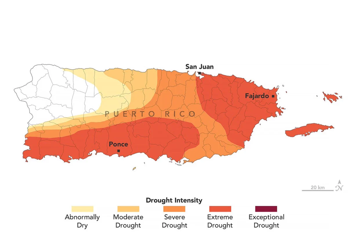
    Puerto Rico’s wet season usually begins in May, but rainfall has been low this year. By late August, drought had spread across much of Puerto Rico, contributing to water shortages and rationing in some areas. NASA data is helping scientists track drought conditions.
    Map of Puerto Rico showing drought conditions as of August 25, 2026. Much of the island is shaded yellow, orange, and dark orange, indicating moderate, severe and extreme drought conditions. Credit: NASA
    6
  • @NASAEarth
    NASA Earth
    NASA
    @NASAEarth
    Sep 2
    From Texas to Maine, coastal wetlands and marshes are releasing over 1.45 billion pounds of carbon into the ocean each year. The finding comes from a study analyzing Landsat images and @USGS elevation data to track marsh loss in the area from 1985-2022. go.nasa.gov/3UxjvVD
    Astronaut photograph of the Mississippi River Delta captured from the International Space Station in 1985. The bird's-foot delta of the Mississippi River extends into the dark blue Gulf. Plumes of muddy tan sediment plumes swirl with bright turquoise coastal waters. Offshore, the water is a dark blue. Credit: NASA
    9
  • @NASAEarth
    NASA Earth
    NASA
    @NASAEarth
    Aug 31
    Emperor penguins living in Antarctica rely on fast ice – sea ice that is attached to the shoreline – to breed, raise chicks, and molt. As sea ice declines, scientists are using @NASA satellite data to understand how penguins responded to sea ice disruptions in the past. 🐧
    Photograph of adult and juvenile emperor penguins congregating on sea ice in Antarctica. The adults are taller, more slender, and are white and black with distinct yellow collars. The juveniles are shorter, rounder, and have puffier gray fur. Credit: Michael Van Woert, NOAA NESDIS, ORA
    16
  • @NASAEarth
    NASA Earth
    NASA
    @NASAEarth
    Aug 26
    It’s #NationalParkWeek! ⛰️🥾🌲 Can you identify these @NatlParkService parks from space? Check out these satellite images and drop your guesses in the comments. Bonus points if you’ve visited or can identify any iconic landmarks!
    Landsat 9 image of a National Park and the surrounding area covered in snow. The area is mountainous, but a dark black jagged line below and left of center stands out in this image. Near the top right corner is a blue lake. Credit: NASA
    Landsat 9 image of a National Park. The image is mostly covered in dark blue water. Green areas arc throughout the image, surrounded by bright blue waters. Bright strips of white sand stand out against the cooler colors. Credit: NASA
    Landsat 8 image of a National Park. The image is mostly various shades of tan and brown. A town is visible at the bottom of the image. A river curves around the town and through the landscape. Credit: NASA
    13
Advertisement
Advertisement