Log inSign up
NOAA
21K posts
Image
user avatar
NOAA
@NOAA
NOAA provides science, service and stewardship to protect life, property & Earth's natural resources. An agency of @CommerceGov. Join us on Instagram & Facebook
USA (Formerly @usNOAAgov)
noaa.gov
Joined April 2008
158
Following
1.3M
Followers
RepliesRepliesMediaMedia

New to X?

Sign up now to get your own personalized timeline!

Create account

By signing up, you agree to the Terms of Service and Privacy Policy, including Cookie Use.

Terms·Privacy·Cookies·Accessibility·Ads Info·© 2026 X Corp.
Don't miss what's happening
People on X are the first to know.
Log inSign up
  • NOAA reposted
    user avatar
    National Weather Service
    @NWS
    Jul 10
    From the Intermountain West to the northern Plains, the first widespread and significant heat wave of the summer is expected to develop today and intensify through this weekend. Widespread triple digit high temperatures are expected by Saturday afternoon, possibly reaching the
    Image
    GIF
    35K
  • NOAA reposted
    user avatar
    NWS Weather Prediction Center
    @NWSWPC
    Jul 10
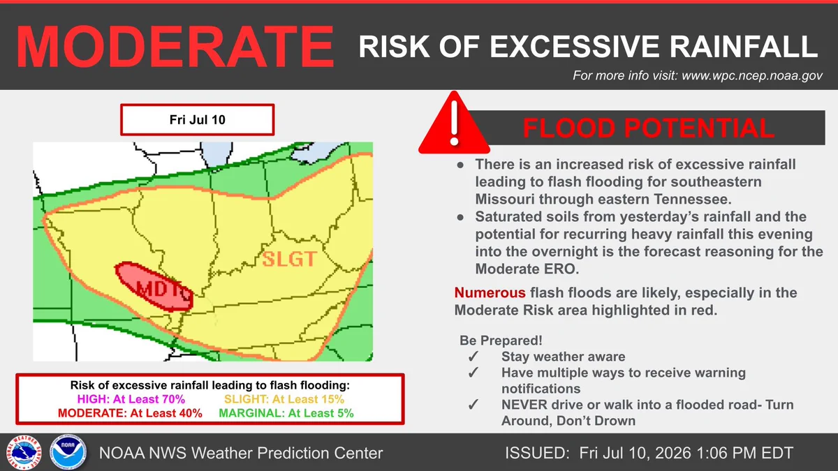
    The flash flood risk is increasing across southeastern Missouri into the Tennessee Valley for this evening into the overnight hours as rounds of heavy rainfall fall over saturated soils. Turn around, don't drown.
    The flash flood risk is increasing across southeastern Missouri into the Tennessee Valley for this evening into the overnight hours as rounds of heavy rainfall fall over saturated soils. Turn around, don't drown.
    21K
  • user avatar
    NOAA
    @NOAA
    Jul 9
    Also out today: Our Monthly Global Temperature & Precip Report ...
    user avatar
    NOAA NCEI
    @NOAANCEI
    Jul 9
    The planet’s thermostat was set to high this #June2026. 🌡️ From record-high ocean temps to a busy storm season, June 2026 was the second-warmest on record with a top-10 low sea ice extent. See the full report: bit.ly/Global202606
    Map of the global temperature percentiles for June 2026 with warmer areas in gradients of red and orange, cooler areas in gradients of blue and gray indicates that it tied with more than 10% of the record.
    15K
  • NOAA reposted
    user avatar
    NIDIS Drought.gov
    @NOAADrought
    Jul 9
    Next week looks relatively wet for the southern US (monsoon in the Southwest) and drier for the Northern/Central Plains and Midwest. Temps: Warmer than normal chances for almost all of the US except the Northeast and Alaska. Drought.gov @NOAA @NWS
    A NOAA 6–10 Day Precipitation Outlook map for the United States, issued July 8, 2026, and valid July 14–18, 2026, showing the probability of above-, near-, or below-normal precipitation. The map indicates a high probability of below-normal precipitation centered over the Upper Midwest and Great Lakes regions, while above-normal precipitation is favored across the Southwest, Southern Plains, Southeast, Alaska, and Hawaii, with the remaining regions leaning near normal.
    A NOAA 6–10 Day Temperature Outlook map for the United States, issued July 8, 2026, and valid July 14–18, 2026, showing the probability of above-, near-, or below-normal temperatures. The map highlights a strong likelihood of above-normal temperatures across the vast majority of the continental United States and Hawaii, centered heavily over the Northern Rockies and Northern Plains, while below-normal temperatures are favored for most of Alaska and northern New England.
    8K
  • NOAA reposted
    user avatar
    NIDIS Drought.gov
    @NOAADrought
    Jul 9
    #DroughtMonitor 7/7: Spotty precip led to very localized improvements and degradations. Many states saw both. States w/ large degradations: OR, WY, CO, NC, SC States w/ large improvements: ID, MT, KS, AR, NJ #Drought2026 Footprint: 39.6% of the US drought.gov @NOAA
    Map of the U.S. Drought Monitor for the total United States, valid July 7, 2026, illustrating drought intensity categories and regional impact types. Widespread severe to exceptional drought (D2–D4) is heavily concentrated across the Intermountain West, the Southwest, and sections of the Southern Plains and Southeast. In contrast, the Midwest and Great Lakes regions remain largely drought-free, while the inset maps show only localized patches of abnormally dry to moderate drought conditions in Alaska, Hawaii, and Puerto Rico.
    6.7K
  • user avatar
    NOAA
    @NOAA
    Jul 9
    Our Monthly U.S. Temperature & Precipitation Report is out today, this time for June:
    user avatar
    NOAA NCEI
    @NOAANCEI
    Jul 9
    Whoa! It was a wet and stormy June across the South and Midwest! ⛈️ From record tornado activity in the Midwest to major rain in Hawai’i, June was quite a roller coaster. Check out the full report: bit.ly/USClimate202606
    Map of the U.S. showing temperature percentiles for June 2026 with warmer areas in gradients of red and cooler areas in gradients of blue.
    10K
  • NOAA reposted
    user avatar
    National Weather Service
    @NWS
    Jul 9
    Severe thunderstorms posing a risk for strong gusts and/or large hail are possible across portions of the northern and central Plains, the Lower Missouri to Lower Ohio Valleys, and across the Mid-Atlantic Thursday afternoon and evening. Excessive rainfall may bring flash and
    US weather map showing widespread rain/thunderstorm risk across the central and eastern states, red crosshatch over parts of MO/IL/OH for heavy rain/flash‑flood risk, yellow hatched corridor from ND into KS for possible severe storms, with fronts and highs/lows; valid Jul 9, 2026.
    59K
  • NOAA reposted
    user avatar
    NWS Weather Prediction Center
    @NWSWPC
    Jul 8
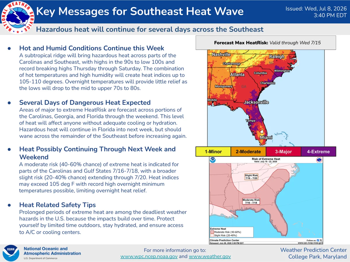
    Dangerous heat wave continues across the Southeast & Carolinas into next week. Highs in the 90s-100s & high humidity will push heat indices to 105-110°F, bringing major to extreme HeatRisk. Stay safe: limit outdoor time & stay hydrated!
    A subtropical ridge will bring hazardous heat across parts of the Carolinas and Southeast, with highs in the 90s to low 100s and record breaking highs Thursday through Saturday. The combination of hot temperatures and high humidity will create heat indices up to 105-110 degrees. Overnight temperatures will provide little relief as the lows will drop to the mid to upper 70s to 80s. 

Areas of major to extreme HeatRisk are forecast across portions of the Carolinas, Georgia, and Florida through the weekend. This level of heat will affect anyone without adequate cooling or hydration. Hazardous heat will continue in Florida into next week, but should wane across the remainder of the Southeast before increasing again.

Prolonged periods of extreme heat are among the deadliest weather hazards in the U.S. because the impacts build over time. Protect yourself by limited time outdoors, stay hydrated, and ensure access to A/C or cooling centers.
    25K
  • NOAA reposted
    user avatar
    NWS Weather Prediction Center
    @NWSWPC
    Jul 9
    There is a Slight Risk (level 2/4) of excessive rainfall over parts of the Central Appalachians, Ohio Valley/Middle Mississippi Valley on Friday wpc.ncep.noaa.gov/discussions/hp…
    13K
  • NOAA reposted
    user avatar
    NWS Weather Prediction Center
    @NWSWPC
    Jul 9
    There is a Slight Risk (level 2/4) of excessive rainfall over parts of the Mid-Atlantic/Central Appalachians, Ohio Valley/Middle Mississippi Valley/Great Lakes and Central High Plains on Thursday wpc.ncep.noaa.gov/discussions/hp…
    12K
  • NOAA reposted
    user avatar
    NWS Weather Prediction Center
    @NWSWPC
    Jul 9
    There is a Slight Risk (level 2/5) of severe thunderstorms over parts of the Mid-Atlantic, Ohio Valley/Middle Mississippi Valley, and Northern/Central High Plains on Thursday wpc.ncep.noaa.gov/discussions/hp…
    13K
  • NOAA reposted
    user avatar
    National Weather Service
    @NWS
    Jul 8
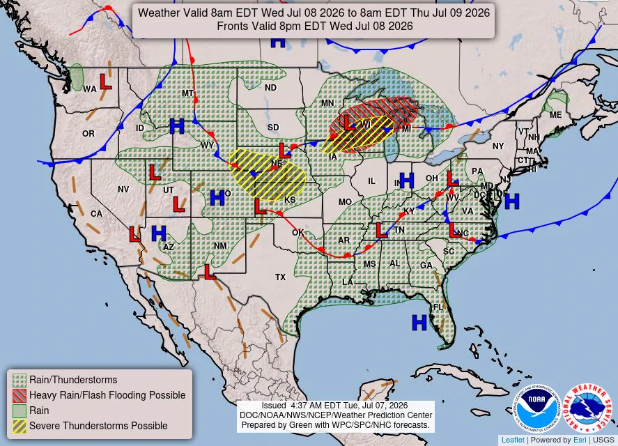
    In the Upper Midwest, heavy to excessive rain may bring flash and urban flooding through Wednesday. Scattered severe thunderstorms capable of large hail and damaging wind gusts are possible from the central High Plains into the Upper Midwest Wednesday.
    National weather map valid 8am EDT Jul 8, 2026 showing widespread rain and thunderstorms (green shading) across the central and eastern U.S., red hatched areas for heavy rain/flash flooding, yellow-striped zones for possible severe storms, and surface fronts with H/L centers.
    26K
  • NOAA reposted
    user avatar
    NWS Weather Prediction Center
    @NWSWPC
    Jul 8
    Dangerous Heat Continues Across the Southeast and Southwest wpc.ncep.noaa.gov/discussions/hp…
    13K
  • NOAA reposted
    user avatar
    NWS Weather Prediction Center
    @NWSWPC
    Jul 8
    There is a Slight Risk (level 2/5) of severe thunderstorms over parts of the Ohio Valley/Middle Mississippi Valley and Central/Southern High Plains on Thursday wpc.ncep.noaa.gov/discussions/hp…
    14K
Advertisement
Advertisement