Log inSign up
National Weather Service
46.6K posts
Image
user avatar
National Weather Service
@NWS
Official X account for @NOAA's National Weather Service. A list of official NWS accounts can be found at x.com/i/lists/725042…
United States
weather.gov
Joined January 2012
323
Following
3.1M
Followers
RepliesRepliesMediaMedia

New to X?

Sign up now to get your own personalized timeline!

Create account

By signing up, you agree to the Terms of Service and Privacy Policy, including Cookie Use.

Terms·Privacy·Cookies·Accessibility·Ads Info·© 2026 X Corp.
Don't miss what's happening
People on X are the first to know.
Log inSign up
  • user avatar
    National Weather Service
    @NWS
    5h
    [Posted 7:30 AM ET July 12, 2026] Heavy rainfall and severe thunderstorms possible for portions of the Ohio/Tennessee Valleys to the Southeast today. Record heat expands for the west to northern Plains including fire weather risks. Be sure to check weather.gov for
    For today' weather highlights:  ●	Scattered severe thunderstorms capable of producing wind damage will be possible across much of the Southeast today and southern Arizona, with the greatest potential for South Carolina. Slight Risk (level 2 of 5) of severe thunderstorms outlooked.
●	Heavy to excessive rainfall with flash flooding potential will continue from portions of the Tennessee Valley to the Carolinas today. Slight Risk (level 2 of 4) of excessive rainfall outlooked.
●	Widespread significant heat wave for the Intermountain West and Plains will continue today and through the week. This could produce numerous daily high, monthly, and all time temperature records. Risk for rapid onset of drought for Northern Plains.
●	Areas of major to extreme HeatRisk are forecast across portions of the Carolinas, Georgia, and Florida today and most of this week.
●	Gusty winds and low relative humidity will create areas of elevated to critical fire weather across parts of the interior Western U.S.
    28K
  • National Weather Service reposted
    user avatar
    NWS Weather Prediction Center
    @NWSWPC
    21h
    Dangerous and record-breaking heat will continue across the Intermountain West and North-Central U.S. through at least midweek, with heat persisting beyond next weekend as well. Be sure to follow proper heat safety tips!
    Extreme Heat Through Midweek
The first widespread significant heat wave of summer for the Intermountain West through the Northern Plains and Upper Great Lakes is expected to impact the region today, peaking in intensity through at least Tuesday. Widespread high temperatures of 95-105 degrees are expected, with local maxima above 110 degrees possible. Even for mid-July, this heat is expected to be exceptionally rare for some locations and produce numerous daily, monthly, and some all-time high temperature records.


Prolonged and Accumulated Heat Stress
Extremely hot daytime highs combined with potentially record-warm lows will result in increasing heat stress over the next several days due to limited relief, leading to widespread Major to locally Extreme HeatRisk. This heat will quickly become dangerous to anyone without adequate cooling or hydration.
    22K
  • National Weather Service reposted
    user avatar
    NWS Weather Prediction Center
    @NWSWPC
    20h
    Over the next 5 days, expect locally heavy rain and and an isolated to scattered flash flood threat for the Southeast and Gulf Coast. Western Texas will see locally heavy rainfall by the middle of the week. The monsoon will bring daily showers and storms to the Southwest.
    Over the next 5 days, expect locally heavy rain and and an isolated to scattered flash flood threat for the Southeast and Gulf Coast. Western Texas will see locally heavy rainfall by the middle of the week. The monsoon will bring daily showers and storms to the Southwest.
    20K
  • user avatar
    National Weather Service
    @NWS
    Jul 11
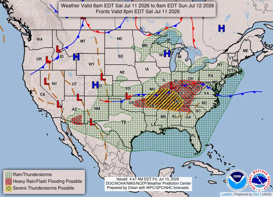
    Severe thunderstorms capable of damaging winds will be possible from the Ozark Plateau east into the Tennessee Valley Saturday. Rounds of heavy thunderstorms ahead of a slow moving front will continue locally heavy rainfall and scattered flash flooding potential from the Ozarks
    U.S. weather map showing widespread rain and thunderstorms across the Southeast and East, a hatched heavy rain/flash‑flood risk centered over the Ohio Valley and Midwest, and a striped zone of possible severe thunderstorms in the central U.S., with frontal boundaries and pressure centers.
    43K
  • National Weather Service reposted
    user avatar
    NWS Weather Prediction Center
    @NWSWPC
    Jul 10
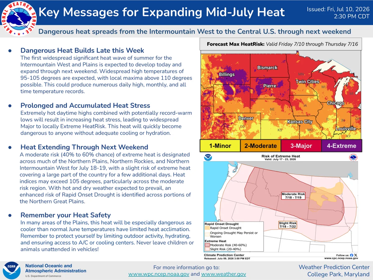
    The latest key message update for the Expanding Mid-July Heat across the Plains and Inter-Mountain West.
    Image
    18K
  • National Weather Service reposted
    user avatar
    NWS St. Louis
    @NWSStLouis
    Jul 10
    Thunderstorms produced 6-12" of rainfall last night through early this morning, producing extensive and catastrophic flash flooding across eastern Missouri. Additional rainfall is expected in the same area through tonight, and a Flood Watch remains in effect. #stlwx #mowx #ilwx
    On the left side of this graphic is a map of estimated rainfall over the last 24 hours ending at 10am, using shades of green and red to highlight rainfall amounts. On the right is white text detailing the impacts and actions.
    50K
  • National Weather Service reposted
    user avatar
    NHC Pacific
    @NHC_Pacific
    Jul 10
    11 AM PDT/8 AM HST Fri, July 10: Four areas are being monitored across the eastern & central North Pacific. Two systems south of Hawaii each have a medium chance of development in 7 days. Another SW of Mexico has a high chance. More: hurricanes.gov
    Image
    15K
  • National Weather Service reposted
    user avatar
    NWS Weather Prediction Center
    @NWSWPC
    Jul 10
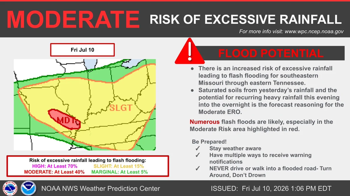
    The flash flood risk is increasing across southeastern Missouri into the Tennessee Valley for this evening into the overnight hours as rounds of heavy rainfall fall over saturated soils. Turn around, don't drown.
    The flash flood risk is increasing across southeastern Missouri into the Tennessee Valley for this evening into the overnight hours as rounds of heavy rainfall fall over saturated soils. Turn around, don't drown.
    21K
  • user avatar
    National Weather Service
    @NWS
    Jul 10
    From the Intermountain West to the northern Plains, the first widespread and significant heat wave of the summer is expected to develop today and intensify through this weekend. Widespread triple digit high temperatures are expected by Saturday afternoon, possibly reaching the
    Image
    GIF
    36K
    user avatar
    National Weather Service
    @NWS
    Jul 10
    Extremely hot daytime highs combined with potentially record-warm overnight lows will result in increasing heat stress, leading to widespread major to locally extreme HeatRisk. This heatwave will quickly become dangerous to anyone without adequate cooling or hydration.
    Extreme Heat: Why is extreme heat so dangerous? Heat becomes especially dangerous if it lingers for more than one day. Hot days and warm nights don’t give our bodies time to cool down. Heat islands can intensify extreme hot weather, which can cause breathing problems, heat cramps, heat stroke, and may lead to illness or even death. What can you do? Check on your friends, family and neighbors during heat waves. Wear light, loose-fitting clothing and drink water often. Don't wait until you are thirsty. Avoid unnecessary hard work or activities if you are outside or in a building without air-conditioning. Stay in an air-conditioned area. Air conditioning is the strongest protective factor against heat-related illness.
    11K
  • user avatar
    National Weather Service
    @NWS
    Jul 10
    When the weather turns, public safety officials and venue staff are your head coaches. 📋They have the emergency "playbook" to keep YOU safe. When they give the signal to evacuate or seek shelter, listen and move fast!
    Image
    23K
  • user avatar
    National Weather Service
    @NWS
    Jul 10
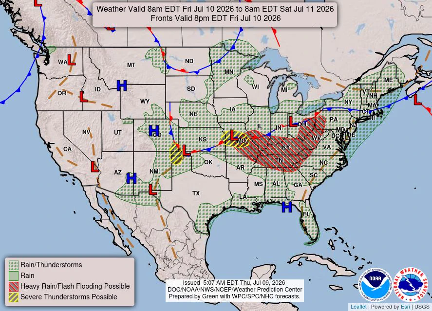
    Severe thunderstorms capable of large hail and damaging wind gusts appear possible over the central and southern High Plains and eastern Kansas into Missouri Friday afternoon and evening. Rounds of storms Friday ahead of a slow moving frontal boundary will bring locally heavy
    U.S. weather map valid Jul 10, 2026 showing widespread rain and thunderstorms, a red‑hatched area over the Midwest and Ohio Valley for heavy rain/flash flooding risk, yellow hatching for possible severe storms, and frontal boundaries with high/low centers.
    72K
  • National Weather Service reposted
    user avatar
    NWS Weather Prediction Center
    @NWSWPC
    Jul 9
    Rounds of storms Friday and Saturday ahead of a slow moving frontal boundary will bring locally heavy rainfall and scattered flash flooding potential to the Ohio and Tennessee Valleys, as well as the Appalachians.
    Rounds of storms Friday and Saturday ahead of a slow moving frontal boundary will bring locally heavy rainfall and scattered flash flooding potential to the Ohio and Tennessee Valleys, as well as the Appalachians.
    18K
  • user avatar
    National Weather Service
    @NWS
    Jul 9
    Most flood fatalities occur in vehicles, and it only takes 12 inches of water to sweep a car away. Sometimes, the difference between life and death is small decisions. weather.gov/safety/flood
    Small Decisions can have a big impact: Flooding. 1) Turn around and don't drive through a flooded roadway. 2) Don't drive around barricades. 3) Delay travel until conditions improve. Don't let a bad decision be your last.
    22K
  • user avatar
    National Weather Service
    @NWS
    Jul 9
    Thunderstorms with severe wind gusts and hail will be possible this afternoon and evening across parts of the central and northern Plains. Severe wind gusts may also occur in parts of the Ozarks, mid Mississippi Valley, lower Ohio Valley, Mid-Atlantic and Arizona. Visit
    NOAA Storm Prediction Center Day 1 Categorical Outlook issued 1255 UTC July 9, 2026, valid from 1300 UTC Thursday, July 9, through 1200 UTC Friday, July 10, 2026. Risk levels shown are dark green = marginal risk, yellow = slight risk, and light green indicates general thunderstorm potential. A broad marginal risk stretches from the northern Plains through the Midwest, Great Lakes, Ohio Valley, and Northeast. Three separate slight risk areas are highlighted: a north-south corridor from eastern Wyoming through western South Dakota into western North Dakota; a region centered on Missouri and southern Illinois extending into western Kentucky and northern Arkansas; and a smaller area over portions of the Delmarva Peninsula, including eastern Maryland and Delaware. Additional thunderstorm potential extends across much of the eastern United States, the Southwest, and Florida.
    99K
Advertisement
Advertisement