1. X
  2. VDOT Northern VA
Log inSign up
VDOT Northern VA
38.7K posts
Image
user avatar
VDOT Northern VA
@VaDOTNOVA
Includes: Arlington, Fairfax, Loudoun, and Prince William counties. Report hazards: my.vdot.virginia.gov or 800-FOR-ROAD.
Northern Virginia
vdot.virginia.gov
Joined May 2013
447
Following
73.6K
Followers
RepliesRepliesMediaMedia

New to X?

Sign up now to get your own personalized timeline!

Create account

By signing up, you agree to the Terms of Service and Privacy Policy, including Cookie Use.

Terms·Privacy·Cookies·Accessibility·Ads Info·© 2026 X Corp.
Don't miss what's happening
People on X are the first to know.
Log inSign up
  • Pinned
    user avatar
    VDOT Northern VA
    @VaDOTNOVA
    Jun 18
    Pssst… You can now find VDOT NOVA on 📸Instagram: @VaDOTNOVA 🧵 Threads: @VaDOTNOVA Come for news and updates. Stay because you’ve become interested in asphalt. See you there!
    2.1K02.1K
  • user avatar
    VDOT Northern VA
    @VaDOTNOVA
    23h
    #Annandale: Little River Turnpike EB lanes closed at John Marr Dr due to a crash. Please use alternate route. #VaTraffic
    2.9K02.9K
  • VDOT Northern VA reposted
    user avatar
    NWS Baltimore-Washington
    @NWS_BaltWash
    Jul 18
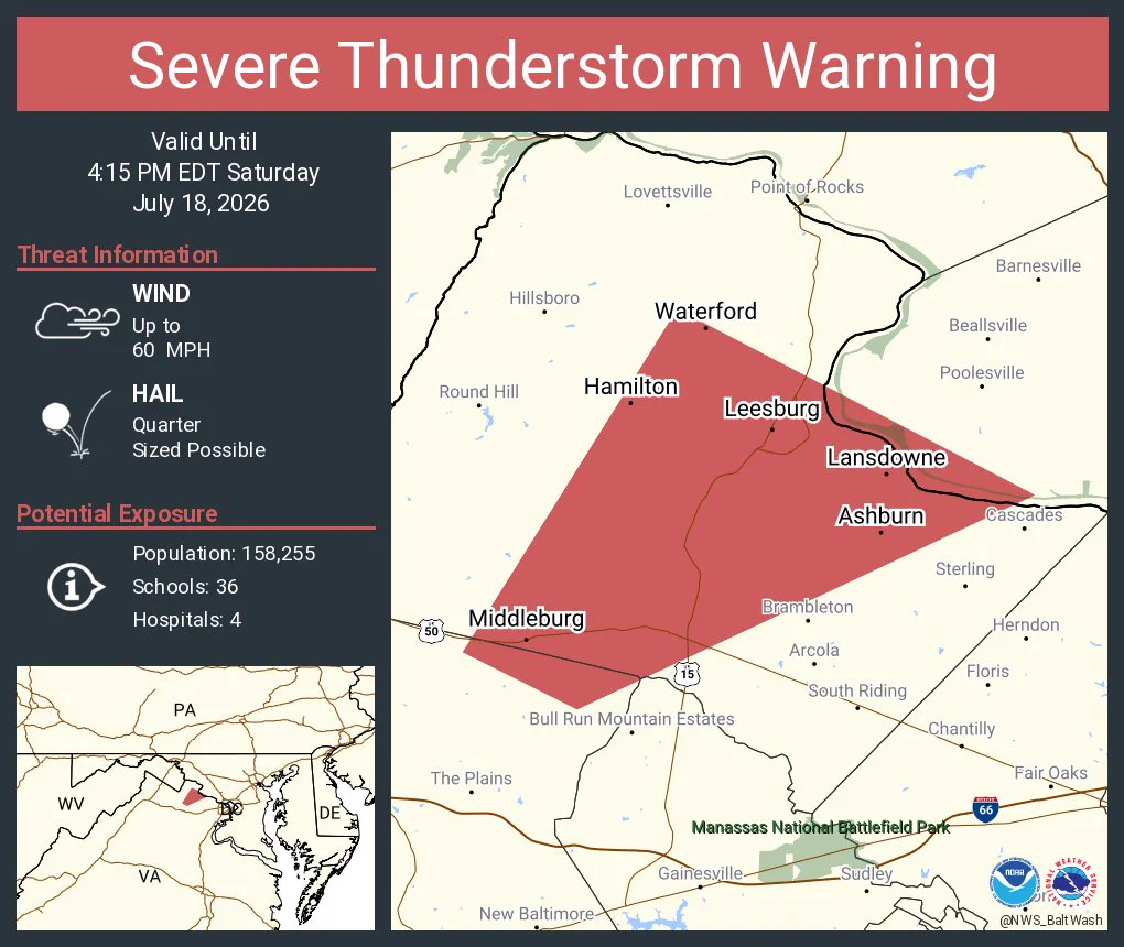
    Severe Thunderstorm Warning including Ashburn VA, Leesburg VA and Broadlands VA until 4:15 PM EDT
    This graphic displays a severe thunderstorm warning plotted on a map. The warning is in effect until 4:15 PM EDT. The warning includes Ashburn VA, Leesburg VA and Broadlands VA.  This warning is for West central Montgomery County in central Maryland, Central Loudoun County in northern Virginia, North central Fauquier County in northern Virginia and Northwestern Prince William County in northern Virginia. The threats associated with this warning are wind gusts up to 60 MPH and quarter sized hail. There are 158,255 people in the warning along with 36 schools and 4 hospitals.
    5.1K05.1K
  • VDOT Northern VA reposted
    user avatar
    NWS Baltimore-Washington
    @NWS_BaltWash
    Jul 18
    Severe Thunderstorm Warning including Centreville VA, Reston VA and McLean VA until 3:45 PM EDT
    This graphic displays a severe thunderstorm warning plotted on a map. The warning is in effect until 3:45 PM EDT. The warning includes Centreville VA, Reston VA and McLean VA.  This warning is for The City of Fairfax in northern Virginia, Northwestern Arlington County in northern Virginia, The City of Falls Church in northern Virginia and Fairfax County in northern Virginia. The threats associated with this warning are wind gusts up to 60 MPH and pea sized hail. There are 984,784 people in the warning along with 165 schools and 6 hospitals.
    4.9K04.9K
  • VDOT Northern VA reposted
    user avatar
    NWS Baltimore-Washington
    @NWS_BaltWash
    Jul 18
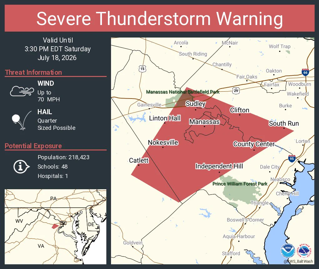
    Severe Thunderstorm Warning continues for Manassas VA, Linton Hall VA and Buckhall VA until 3:30 PM EDT. This storm will contain wind gusts to 70 MPH!
    This graphic displays a severe thunderstorm warning plotted on a map. The warning is in effect until 3:30 PM EDT. The warning includes Manassas VA, Linton Hall VA and Buckhall VA.  This warning is for Southeastern Loudoun County Is Cancelled. The threats associated with this warning are wind gusts up to 70 MPH and quarter sized hail. There are 218,423 people in the warning along with 48 schools and 1 hospital.
    11K011K
  • VDOT Northern VA reposted
    user avatar
    NWS Baltimore-Washington
    @NWS_BaltWash
    Jul 18
    Severe Thunderstorm Warning including Manassas VA, Linton Hall VA and Buckhall VA until 3:30 PM EDT
    This graphic displays a severe thunderstorm warning plotted on a map. The warning is in effect until 3:30 PM EDT. The warning includes Manassas VA, Linton Hall VA and Buckhall VA.  This warning is for Southeastern Loudoun County in northern Virginia, Southwestern Fairfax County in northern Virginia, East central Fauquier County in northern Virginia, The City of Manassas Park in northern Virginia, Central Prince William County in northern Virginia and The City of Manassas in northern Virginia. The threats associated with this warning are wind gusts up to 60 MPH and quarter sized hail. There are 233,807 people in the warning along with 52 schools and 1 hospital.
    4.8K04.8K
  • VDOT Northern VA reposted
    user avatar
    NWS Baltimore-Washington
    @NWS_BaltWash
    Jul 18
    Tornado Warning including Adamstown MD, Point of Rocks MD and Dickerson MD until 2:45 PM EDT
    This graphic displays a tornado warning plotted on a map. The warning is in effect until 2:45 PM EDT. The warning includes Adamstown MD, Point of Rocks MD and Dickerson MD.  This warning is for Northwestern Montgomery County in central Maryland, Southwestern Frederick County in north central Maryland and Northeastern Loudoun County in northern Virginia. The threats associated with this warning are a radar indicated tornado and golf ball sized hail. There are 8,335 people in the warning along with 2 schools and 0 hospitals.
    12K012K
  • VDOT Northern VA reposted
    user avatar
    NWS Baltimore-Washington
    @NWS_BaltWash
    Jul 18
    A severe thunderstorm watch has been issued for parts of District of Columbia, Maryland, North Carolina, Virginia and West Virginia until 9 PM EDT
    This graphic displays Severe Thunderstorm watch number 496 plotted on a map. The watch is in effect until 9:00 PM EDT. The watch includes parts of District of Columbia, Maryland, North Carolina, Virginia and West Virginia. The threats associated with this watch are no tornadoes expected, isolated hail up to ping pong size possible and scattered gusts up to 70 mph likely. There are 16,655,136 people in the watch along with 4014 schools and 206 hospitals.
    6.8K06.8K
  • VDOT Northern VA reposted
    user avatar
    NWS Baltimore-Washington
    @NWS_BaltWash
    Jul 18
    Severe thunderstorms are possible today, especially between 2 and 8 PM this afternoon and evening. Damaging wind gusts, large hail, and even a tornado are possible. Have a plan to receive warnings and take action immediately if warnings are issued.
    Map shows the severe weather outlook today. There is a level 2 and 3 out of five depending on where you are. The level 2 is for locations west of The Blue Ridge into central Virginia and the Piedmont. The level 3 is for the Washington and Baltimore metro areas as well as northern Virginia and most of Maryland near and east of the Catoctin Mountains. Damaging winds, large hail, and even a tornado is possible. The best chance for severe storms will be between 2 and 8 PM this afternoon and evening.
    11K011K
  • user avatar
    VDOT Northern VA
    @VaDOTNOVA
    Jul 17
    🚧Traffic Alert - #Fairfax: From 6 am Sun 7/19 to 5 am Mon 7/20, SB Fairfax County Pkwy will have lane closures between Rt 29 and Popes Head Rd for paving as part of the Fairfax County Parkway north widening project. #VaTraffic @VaTruckingAssn More: bit.ly/4vAmGZk
    VDOT Fairfax County Parkway/Route 286 road work graphic
    2K02K
  • user avatar
    VDOT Northern VA
    @VaDOTNOVA
    Jul 17
    Looks like the air quality in NOVA will be returning to normal through the weekend. Phew!
    user avatar
    Virginia DEQ
    @VirginiaDEQ
    Jul 17
    AIR QUALITY UPDATE Air quality will begin improving throughout the day tomorrow due to the passage of a cold front. View the current air quality & forecast: deq.virginia.gov/air-energy/air…
    DEQ Weekend Air Quality Forecast July 18 to July 20
 
Hampton Roads: Saturday - yellow, Sunday - yellow, Monday - green
Northern Virginia:  Saturday - orange, Sunday - yellow, Monday - yellow
Richmond: Saturday - yellow, Sunday - yellow, Monday - yellow
Roanoke: Saturday - yellow, Sunday - green, Monday - green
Winchester: Saturday - orange, Sunday - yellow, Monday - yellow
    4.7K04.7K
  • VDOT Northern VA reposted
    user avatar
    MATOC Alerts
    @MATOC
    Jul 17
    UPDATE: Tractor Trailer Crash. I-495 SB OL past I-66. Fairfax County, VA. Two left main lanes are blocked. Traffic proceeds in three right lanes. Delays are approximately 3.5 miles.
    1.8K01.8K
  • VDOT Northern VA reposted
    user avatar
    MATOC Alerts
    @MATOC
    Jul 17
    FINAL: Crash. I-66 WB at VA-28. Fairfax County, VA. All lanes are now open, incident activity is contained to the right shoulder and delays are dissipating.
    1.2K01.2K
  • VDOT Northern VA reposted
    user avatar
    MATOC Alerts
    @MATOC
    Jul 17
    UPDATE: Tractor Trailer Crash. I-495 SB OL past I-66. Fairfax County, VA. Three left main lanes are blocked. Traffic proceeds in two right lanes. The Express lanes are now open. Delays are approximately 4 miles.
    1.4K01.4K
Advertisement
Advertisement