1. X
  2. NOAA
Log inSign up
NOAA
21.1K posts
Image
user avatar
NOAA
@NOAA
NOAA provides science, service and stewardship to protect life, property & Earth's natural resources. An agency of @CommerceGov. Join us on Instagram & Facebook
USA (Formerly @usNOAAgov)
noaa.gov
Joined April 2008
161
Following
1.3M
Followers
RepliesRepliesMediaMedia
  • user avatar
    NOAA
    @NOAA
    5h
    Our Monthly *GLOBAL* Temperature and Precipitation is out again today, for July:
    user avatar
    NOAA NCEI
    @NOAANCEI
    5h
    If you thought July 2026 felt like a sauna, you weren't imagining it. We just tied 2024 for the warmest July on record—ocean surface temperatures reached a record high for the month too. 🌍🌡️ Read the full report here: bit.ly/Global202607
    Map of the global temperature percentiles for July 2026 with warmer areas in gradients of red and orange, cooler areas in gradients of blue and gray indicates that it tied with more than 10% of the record.
    Map of world showing locations of temperature highlights in July 2026 with text describing each event and title at top stating “Notable Weather and Climate Events: July 2026”.
  • user avatar
    NOAA
    @NOAA
    Aug 10
    NOAA's Monthly Temperature & Precipitation Report is out again, this time for July 2026 ... The month was a record-setter:
    user avatar
    NOAA NCEI
    @NOAANCEI
    Aug 10
    July 2026 just set a record as the warmest month ever for the contiguous U.S. (76.9°F)! 🌡️ From widespread heat to intense regional flooding, it was a wild weather month. Get the full scoop here: bit.ly/USClimate202607
    Map of the U.S. showing temperature percentiles for July 2026 with warmer areas in gradients of red and cooler areas in gradients of blue.
    Map of the U.S. showing precipitation percentiles for July 2026 with wetter areas in gradients of green and drier areas in gradients of brown.
  • user avatar
    NOAA
    @NOAA
    Aug 6
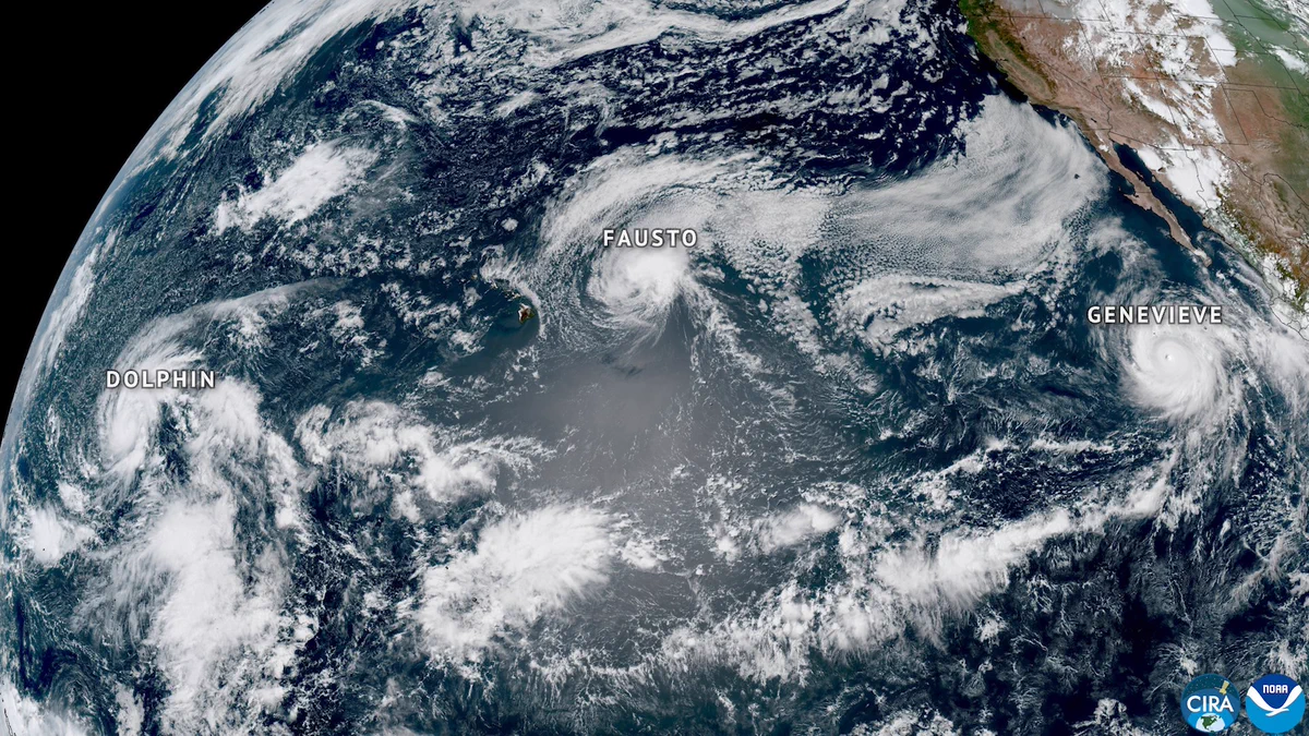
    Did you know that some Pacific hurricanes actually start in the Atlantic Ocean, off Africa? We had two the last week in July. Learn more: noaa.gov/stories/pacifi… via @NOAASatellites
    NOAA's GOES West satellite captured this image of three tropical cyclones — Hurricanes Fausto and Genevieve and Typhoon Dolphin — swirling simultaneously in the Pacific Ocean. The image was taken on Tuesday, July 27, at 3:30 PM PDT/ 22:30 UTC. None of the three tropical cyclones made landfall in the United States. (Credit: NOAA Satellites)
  • user avatar
    NOAA
    @NOAA
    Aug 6
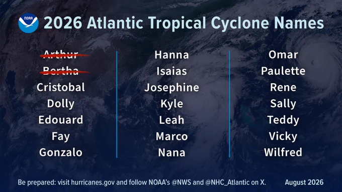
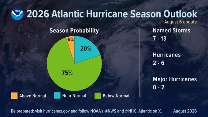
    JUST IN: NOAA's Atlantic Hurricane Season Outlook remains 'below normal,' in August update *U.S. residents need to remain prepared* Details: bit.ly/AtlanticHurric… #HurricaneOutlook @NWS @NWSCPC
    Image
    Image
  • user avatar
    NOAA
    @NOAA
    Aug 5
    Just in: @NOAA and scientific partners find smaller-than-anticipated hypoxic 'dead zone' in Gulf of America News release: noaa.gov/news-release/n… via @noaaocean, @LSU, @LUMCONscience
    Two scientists aboard a ship hoist a large metal instrument over the waters of the Gulf of Mexico.
    NOAA and partners find smaller-than-anticipated hypoxic zone in Gulf of America
    From noaa.gov

Log in or sign up for X

See what’s happening and join the conversation

Continue with phone
or
Log in with username or email
Terms·Privacy·Cookies·Accessibility·Ads Info·© 2026 X Corp.
Advertisement
Advertisement